
File:Range Map - Amanita tecomate.png

Size of this preview: 800 × 561 pixels. Other resolutions: 320 × 224 pixels | 640 × 449 pixels | 1,024 × 718 pixels | 1,378 × 966 pixels.
Original file (1,378 × 966 pixels, file size: 95 KB, MIME type: image/png)
| This is a file from the Wikimedia Commons. Information from its description page there is shown below. Commons is a freely licensed media file repository. You can help. |
Summary
| Description |
English: Depicts georeferenced points of where A. tecomate was recorded. |
| Date | |
| Source | https://www.gbif.org/species/5452704 |
| Author | Guzmán & Ram.-Guill. |
Licensing
This file is licensed under the Creative Commons Attribution-Share Alike 2.5 Generic license.
- You are free:
- to share – to copy, distribute and transmit the work
- to remix – to adapt the work
- Under the following conditions:
- attribution – You must give appropriate credit, provide a link to the license, and indicate if changes were made. You may do so in any reasonable manner, but not in any way that suggests the licensor endorses you or your use.
- share alike – If you remix, transform, or build upon the material, you must distribute your contributions under the same or compatible license as the original.
File history
Click on a date/time to view the file as it appeared at that time.
| Date/Time | Thumbnail | Dimensions | User | Comment | |
|---|---|---|---|---|---|
| current | 04:17, 8 May 2022 | 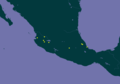 | 1,378 × 966 (95 KB) | Cgranados333 | Uploaded a work by Guzmán & Ram.-Guill. from https://www.gbif.org/species/5452704 with UploadWizard |
File usage
The following pages on the English Wikipedia use this file (pages on other projects are not listed):