
File:RamblesMap.png
No higher resolution available.
RamblesMap.png (597 × 538 pixels, file size: 58 KB, MIME type: image/png)
| This is a file from the Wikimedia Commons. Information from its description page there is shown below. Commons is a freely licensed media file repository. You can help. |
Summary
| Description |
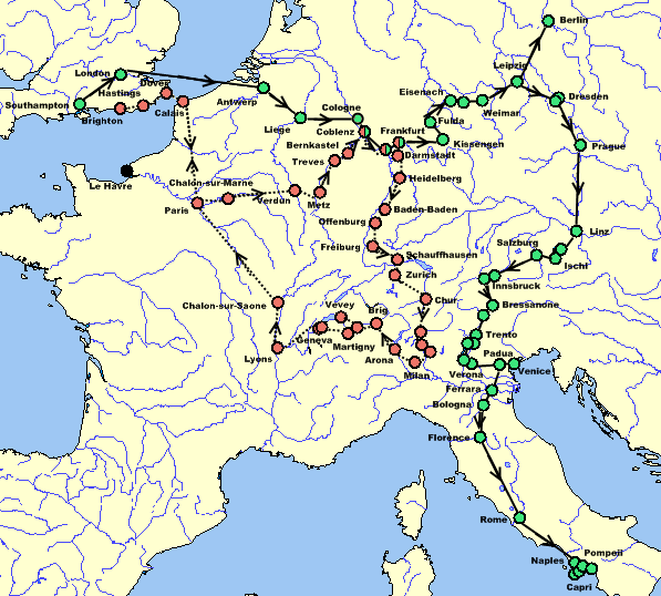
English: Map of Mary Shelley and her son Percy Florence Shelley's travels in 1840 and 1842–1843, taken from The Novels and Selected Works of Mary Shelley. Vol. 8. Ed. Jeanne Moskal. London: William Pickering, 1996, pg. 58–59. The red dots and dotted line indicate the 1840 trip; the green dots and solid line indicate the 1842–43 trip; dual-colored dots indicate places visited on both trips; black dots indicate places not visited but helpful for the reader. |
| Date | |
| Source | Own work by Awadewit, made with Online Map Creation |
| Author | Awadewit |
| Other versions | Derivative works of this file: RamblesMap-es.JPG |
Licensing
I, the copyright holder of this work, hereby publish it under the following licenses:
This file is licensed under the Creative Commons Attribution-Share Alike 3.0 Unported license.
- You are free:
- to share – to copy, distribute and transmit the work
- to remix – to adapt the work
- Under the following conditions:
- attribution – You must give appropriate credit, provide a link to the license, and indicate if changes were made. You may do so in any reasonable manner, but not in any way that suggests the licensor endorses you or your use.
- share alike – If you remix, transform, or build upon the material, you must distribute your contributions under the same or compatible license as the original.

|
Permission is granted to copy, distribute and/or modify this document under the terms of the GNU Free Documentation License, Version 1.2 or any later version published by the Free Software Foundation; with no Invariant Sections, no Front-Cover Texts, and no Back-Cover Texts. A copy of the license is included in the section entitled GNU Free Documentation License. |
You may select the license of your choice.
File history
Click on a date/time to view the file as it appeared at that time.
| Date/Time | Thumbnail | Dimensions | User | Comment | |
|---|---|---|---|---|---|
| current | 05:47, 16 December 2008 |  | 597 × 538 (58 KB) | Awadewit | adding arrows |
| 05:17, 10 November 2008 |  | 597 × 538 (56 KB) | Awadewit | adding arrows | |
| 15:02, 6 August 2008 |  | 597 × 538 (37 KB) | Ruhrfisch | Awadewit's map, I just fixed the color of the seas. | |
| 14:13, 6 August 2008 |  | 597 × 538 (37 KB) | Awadewit | {{Information |Description={{en|1=Map of Mary Shelley and her son Percy Florence Shelley's travels in 1840 and 1840-1840, taken from ''The Novels and Selected Works of Mary Shelley''. Vol. 8. Ed. Jeanne Moskal. London: William Pickering, 1996, pg. 58-59. |
File usage
No pages on the English Wikipedia use this file (pages on other projects are not listed).
Global file usage
The following other wikis use this file:
- Usage on de.wikipedia.org
- Usage on it.wikipedia.org