
File:Radar-resolution.PNG
No higher resolution available.
Radar-resolution.PNG (483 × 365 pixels, file size: 37 KB, MIME type: image/png)
| This is a file from the Wikimedia Commons. Information from its description page there is shown below. Commons is a freely licensed media file repository. You can help. |
Summary
| Description |
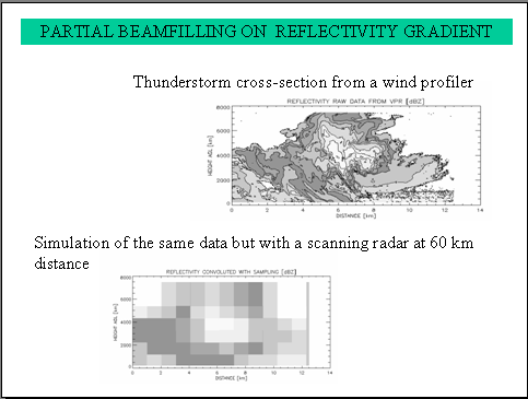
English: Comparison of high resolution data of a cross-section of a thunderstorm taken from a wind profiler just under the cloud and what a scanning weather radar would see at 60 km distance. |
| Date | |
| Source | Own work |
| Author | Pierre cb |
Licensing
I, the copyright holder of this work, hereby publish it under the following license:

|
Permission is granted to copy, distribute and/or modify this document under the terms of the GNU Free Documentation License, Version 1.2 or any later version published by the Free Software Foundation; with no Invariant Sections, no Front-Cover Texts, and no Back-Cover Texts. A copy of the license is included in the section entitled GNU Free Documentation License. |
| This file is licensed under the Creative Commons Attribution-Share Alike 3.0 Unported license. | ||
| ||
| This licensing tag was added to this file as part of the GFDL licensing update. |
File history
Click on a date/time to view the file as it appeared at that time.
| Date/Time | Thumbnail | Dimensions | User | Comment | |
|---|---|---|---|---|---|
| current | 15:39, 8 May 2006 |  | 483 × 365 (37 KB) | Pierre cb | Comparison of high resolution data of a cross-section of a thunderstorm taken from a wind profiler just under the cloud and what a scanning weather radar would see at 60 km distance. Source: Pierre_cb 2006-05-08 |
File usage
The following pages on the English Wikipedia use this file (pages on other projects are not listed):
Global file usage
The following other wikis use this file:
- Usage on es.wikipedia.org