
File:Queen-Elizabeth-map.png

Size of this preview: 766 × 600 pixels. Other resolutions: 307 × 240 pixels | 613 × 480 pixels | 847 × 663 pixels.
Original file (847 × 663 pixels, file size: 208 KB, MIME type: image/png)
| This is a file from the Wikimedia Commons. Information from its description page there is shown below. Commons is a freely licensed media file repository. You can help. |
Summary
| Description |
English: A map showing the location of the Queen Elizabeth neighbourhood in relation to the other neighbourhoods in Saskatoon. |
| Date | |
| Source | http://www.saskatoon.ca/DEPARTMENTS/Community%20Services/PlanningDevelopment/Documents/Research/Neighbourhood_profiles/2007/queen_elizabeth.pdf |
| Author | City of Saskatoon - Planning & Development Branch |
| Permission (Reusing this file) |
Licensing

|
The copyright holder of this file allows anyone to use it for any purpose, provided that the copyright holder is properly attributed. Redistribution, derivative work, commercial use, and all other use is permitted. |
|
|
File history
Click on a date/time to view the file as it appeared at that time.
| Date/Time | Thumbnail | Dimensions | User | Comment | |
|---|---|---|---|---|---|
| current | 23:32, 25 December 2010 | 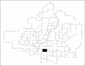 | 847 × 663 (208 KB) | Drm310 | Updated version from 2010 |
| 05:38, 27 January 2010 | 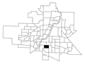 | 330 × 250 (22 KB) | Drm310 | {{Information |Description={{en|1=A map showing the location of the Queen Elizabeth neighbourhood in relation to the other neighbourhoods in Saskatoon.}} |Source=http://www.saskatoon.ca/DEPARTMENTS/Community%20Services/PlanningDevelopment/Documents/Resear |
File usage
The following pages on the English Wikipedia use this file (pages on other projects are not listed):
Global file usage
The following other wikis use this file:
- Usage on www.wikidata.org