
File:Pyrenees-Atlantiques-fr-cropped.png

Size of this preview: 800 × 360 pixels. Other resolutions: 320 × 144 pixels | 640 × 288 pixels | 1,024 × 461 pixels | 1,738 × 782 pixels.
Original file (1,738 × 782 pixels, file size: 2.26 MB, MIME type: image/png)
| This is a file from the Wikimedia Commons. Information from its description page there is shown below. Commons is a freely licensed media file repository. You can help. |
Summary
| Description |
English: Map of French department of Pyrenees-Atlantiques cropped to show only the area between Bayonne and Orthez. |
| Date | |
| Source | Wikipedia Commons map File:Pyrenees-Atlantiques topographic map-fr.jpg. Cropped to a smaller area to show the 1814 military campaign of Bayonne and Orthez. |
| Author | Eric Gaba (fr:User:sting) |
Licensing
This file is licensed under the Creative Commons Attribution-Share Alike 4.0 International license.
- You are free:
- to share – to copy, distribute and transmit the work
- to remix – to adapt the work
- Under the following conditions:
- attribution – You must give appropriate credit, provide a link to the license, and indicate if changes were made. You may do so in any reasonable manner, but not in any way that suggests the licensor endorses you or your use.
- share alike – If you remix, transform, or build upon the material, you must distribute your contributions under the same or compatible license as the original.
File history
Click on a date/time to view the file as it appeared at that time.
| Date/Time | Thumbnail | Dimensions | User | Comment | |
|---|---|---|---|---|---|
| current | 03:54, 17 December 2016 | 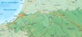 | 1,738 × 782 (2.26 MB) | Djmaschek | User created page with UploadWizard |
File usage
The following pages on the English Wikipedia use this file (pages on other projects are not listed):
Global file usage
The following other wikis use this file:
- Usage on es.wikipedia.org
- Usage on ru.wikipedia.org