
File:Priestley House Map.png
No higher resolution available.
Priestley_House_Map.png (529 × 500 pixels, file size: 20 KB, MIME type: image/png)
| This is a file from the Wikimedia Commons. Information from its description page there is shown below. Commons is a freely licensed media file repository. You can help. |
| Description |
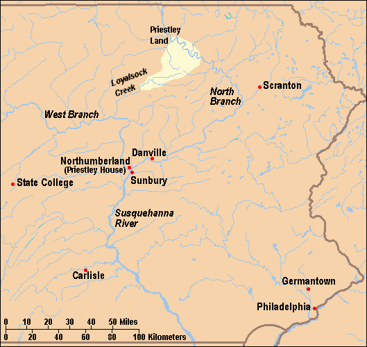
English: Map of locations mentioned in the Joseph Priestley House article in eastern Pennsylvania, United States. House is in Northumberland, Pennsylvania.
Français : Carte montrant les lieux mentionnés dans l'article concernant la Joseph Priestley House de Northumberland en Pennsylvanie. |
| Date | |
| Source | taken from US Census website [1] and modified by User:Ruhrfisch. Information for Priestley sons' land along Loyalsock Creek and North Branch of Susquehanna River based on Joseph Preistley House brochure map from the Pennsylvania Historical and Museum Commission. |
| Author | US Census, Ruhrfisch |
| Permission (Reusing this file) |
US Census / US Government work is public domain, my modifications licensed under the GNU Free Documentation License |
| Other versions | Used as the larger map in both Image:Priestley House Map with inset.png and Image:Priestley House Map with inset 1.png. |

|
Permission is granted to copy, distribute and/or modify this document under the terms of the GNU Free Documentation License, Version 1.2 or any later version published by the Free Software Foundation; with no Invariant Sections, no Front-Cover Texts, and no Back-Cover Texts. A copy of the license is included in the section entitled GNU Free Documentation License. |
| This file is licensed under the Creative Commons Attribution-Share Alike 3.0 Unported license. | ||
| ||
| This licensing tag was added to this file as part of the GFDL licensing update. |
File history
Click on a date/time to view the file as it appeared at that time.
| Date/Time | Thumbnail | Dimensions | User | Comment | |
|---|---|---|---|---|---|
| current | 23:32, 10 April 2009 |  | 529 × 500 (20 KB) | Mahahahaneapneap | Compressed |
| 20:13, 22 January 2008 |  | 529 × 500 (33 KB) | Ruhrfisch | Add Carlisle, PA dot and label (as now in the article), all other information the same | |
| 16:47, 11 January 2008 |  | 529 × 500 (33 KB) | Ruhrfisch | Removed "PENNSYLVANIA", added 10s to miles scale and 20s to kilometers scale, all other information the same | |
| 04:21, 11 January 2008 |  | 529 × 500 (33 KB) | Ruhrfisch | Move Danville label west to keep North Branch clearly displayed, all other info the same. | |
| 04:05, 11 January 2008 |  | 529 × 500 (33 KB) | Ruhrfisch | {{Information| |Description= Map of locations mentioned in the Joseph Priestley House article in eastern Pennsylvania, United States. House is in Northumberland, Pennsylvania. |Source= taken from US Census website [http://fac |
File usage
The following pages on the English Wikipedia use this file (pages on other projects are not listed):
- Joseph Priestley House
- Talk:Joseph Priestley House/Archive 1
- User:Gerry D/archive7
- User:Ruhrfisch/map
- User talk:Ben MacDui/Archive 5
- User talk:Coldupnorth/Archive9
- User talk:Daniel Case/Archive 12/7/2007-3/12/2008
- User talk:Doc glasgow/Feb 08
- User talk:Doncram/Archive 2
- User talk:Epbr123/Archive 2
- User talk:Karanacs/Archive 4
- User talk:Wadewitz/Archive 23
- User talk:Yllosubmarine/Archive 4
- Wikipedia talk:WikiProject National Register of Historic Places/Archive 6
- Wikipedia talk:WikiProject Pennsylvania/Archive 3
Global file usage
The following other wikis use this file:
- Usage on fr.wikipedia.org