
File:Position fortifiee namur - Vue d'ensemble.jpg

Size of this preview: 800 × 587 pixels. Other resolutions: 320 × 235 pixels | 640 × 469 pixels | 1,024 × 751 pixels | 1,280 × 939 pixels | 1,500 × 1,100 pixels.
Original file (1,500 × 1,100 pixels, file size: 510 KB, MIME type: image/jpeg)
| This is a file from the Wikimedia Commons. Information from its description page there is shown below. Commons is a freely licensed media file repository. You can help. |
Summary
| Description |
English: A global map of the 9 forts surrounding the city of Namur in Belgium. Those where build under the Design of Belgian army general Henri Alexis Brialmont in 1889-1892.
Forts are represented in red. When an external air intake tower was added (around 1930), it's position is mentionned via a small red circle. Purple squares are infantery shelters (bunkers) in intervals between the forts, as built between WW I and II Français : Carte globale des 9 forts entourant Namur (Belgique) Ces forts furent concus par le général Henri Alexis Brialmont en 1889-1892.
Sur la carte, les forts sont représentés en rouge. Lorsqu'une "tour d'air" externe leur a été adjointe, elle est représentée par un petit rond rouge relié au fort Les carrés mauves représentent les bunkers construits entre les deux guerres afin de protéger l'infanterie présente dasn les intervalles entre les forts, offrant uen meilleure protection que les abris de tôle des tranchées de la première guerre mondiale |
| Date | |
| Source | OpenStreetMap.org |
| Author | adapted by Noben k |
Carte basée sur le rendu HistOSM de OpenStreetMap
Licensing
This file is licensed under the Creative Commons Attribution-Share Alike 2.5 Generic license.
- You are free:
- to share – to copy, distribute and transmit the work
- to remix – to adapt the work
- Under the following conditions:
- attribution – You must give appropriate credit, provide a link to the license, and indicate if changes were made. You may do so in any reasonable manner, but not in any way that suggests the licensor endorses you or your use.
- share alike – If you remix, transform, or build upon the material, you must distribute your contributions under the same or compatible license as the original.
File history
Click on a date/time to view the file as it appeared at that time.
| Date/Time | Thumbnail | Dimensions | User | Comment | |
|---|---|---|---|---|---|
| current | 18:09, 14 October 2012 | 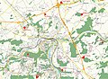 | 1,500 × 1,100 (510 KB) | Noben k | map updated to add missing elements (bunkers on the east side of this defense line) |
| 00:42, 3 October 2012 |  | 1,500 × 1,100 (683 KB) | Noben k | User created page with UploadWizard |
File usage
The following pages on the English Wikipedia use this file (pages on other projects are not listed):
Global file usage
The following other wikis use this file:
- Usage on fr.wikipedia.org
- Usage on nl.wikipedia.org