
File:Plebiscito 1988 mapa por comunas.svg

Size of this PNG preview of this SVG file: 447 × 599 pixels. Other resolutions: 179 × 240 pixels | 358 × 480 pixels | 573 × 768 pixels | 764 × 1,024 pixels | 1,528 × 2,048 pixels | 811 × 1,087 pixels.
Original file (SVG file, nominally 811 × 1,087 pixels, file size: 2.28 MB)
| This is a file from the Wikimedia Commons. Information from its description page there is shown below. Commons is a freely licensed media file repository. You can help. |
Summary
| Description |
Español: Mapa del resultado por comunas del plebiscito de Chile de 1988 sobre la permanencia de Augusto Pinochet en el poder. Las comunas han sido coloreadas según el porcentaje alcanzado en dichas circunscripciones. |
| Date | |
| Source | own, map by James2813 - Trabajo propio, CC BY-SA 4.0, https://commons.wikimedia.org/w/index.php?curid=112216215} |
| Author | MP DDT |
Licensing
I, the copyright holder of this work, hereby publish it under the following license:
This file is licensed under the Creative Commons Attribution-Share Alike 4.0 International license.
- You are free:
- to share – to copy, distribute and transmit the work
- to remix – to adapt the work
- Under the following conditions:
- attribution – You must give appropriate credit, provide a link to the license, and indicate if changes were made. You may do so in any reasonable manner, but not in any way that suggests the licensor endorses you or your use.
- share alike – If you remix, transform, or build upon the material, you must distribute your contributions under the same or compatible license as the original.
File history
Click on a date/time to view the file as it appeared at that time.
| Date/Time | Thumbnail | Dimensions | User | Comment | |
|---|---|---|---|---|---|
| current | 23:39, 17 March 2023 |  | 811 × 1,087 (2.28 MB) | MP DDT | Modificación de los límites de las comunas de Lo Espejo y Pedro Aguirre Cerda según lo dispuesto en el DFL N.º 1-3260 (siendo esta la división vigente hasta la publicación el 5 de diciembre de 1989 del DFL N.º 3-18715) |
| 23:06, 16 March 2023 |  | 811 × 1,087 (2.28 MB) | MP DDT | Corrección del límite de las comunas de Cerrillos, Maipú, Pedro Aguirre Cerda y Santiago en el mapa no ampliado de Santiago | |
| 11:00, 11 March 2023 | 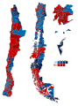 | 811 × 1,087 (2.18 MB) | MP DDT | Modificación de límites comunales en Maipú-Cerrillos (según el DFL N.º 38-18992 de 21-10-1991), Santiago-Pedro Aguirre Cerda (según DFL N.º 37-18992 de 21-10-1991) y supresión de la comuna de Padre Las Casas (creada por la Ley N.° 19391 de 2-6-1995) | |
| 23:14, 14 March 2022 | 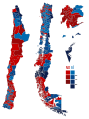 | 811 × 1,087 (2.17 MB) | MP DDT | Modificación del espacio entre los recuadros de colores y la posición de los números | |
| 18:28, 14 March 2022 |  | 811 × 1,087 (2.17 MB) | MP DDT | Uploaded own work with UploadWizard |
File usage
The following pages on the English Wikipedia use this file (pages on other projects are not listed):
Global file usage
The following other wikis use this file:
- Usage on es.wikipedia.org
- Usage on it.wikipedia.org