
File:Piper and Quehanna Wild Area Aerial 1958 crop.jpg

Size of this preview: 748 × 600 pixels. Other resolutions: 299 × 240 pixels | 599 × 480 pixels | 945 × 758 pixels.
Original file (945 × 758 pixels, file size: 521 KB, MIME type: image/jpeg)
| This is a file from the Wikimedia Commons. Information from its description page there is shown below. Commons is a freely licensed media file repository. You can help. |
Summary
| Description | Aerial photo of w:Quehanna Wild Area and the surrounding Moshannon State Forest in Clearfield County, Pennsylvania in the United States. North is up. The Quehanna Highway is the curving vertical road on the left side. It passes through what was then known as Quehanna and in 2010 known as Piper Boot Camp, originally an industrial facility set up by Curtiss-Wright Corp. The small diagonal road running to the right side leads to the Piper Reservoir on the stream named Upper Three Runs. | |||
| Date | Photo taken 05/21/1958 | |||
| Source | File is [1] at the Penn Pilot website, "a project sponsored by the Pennsylvania Geological Survey, is an online library of digital historical aerial photography for the Commonwealth of Pennsylvania." Original file name was "clearfield_052158_app_4v_126.jpg" | |||
| Author | According to this, "The photos were produced by the United States Department of Agriculture, Agricultural Adjustment Administration (now known as the Farm Service Agency)." | |||
| Permission (Reusing this file) |
|
|||
| Other versions |
 |
Licensing
This image or file is a work of a United States Department of Agriculture employee, taken or made as part of that person's official duties. As a work of the U.S. federal government, the image is in the public domain.
|
 |
File history
Click on a date/time to view the file as it appeared at that time.
| Date/Time | Thumbnail | Dimensions | User | Comment | |
|---|---|---|---|---|---|
| current | 02:41, 12 March 2010 | 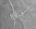 | 945 × 758 (521 KB) | Ruhrfisch | == {{int:filedesc}} == {{Information |Description= Aerial photo of w:Quehanna Wild Area and the surrounding Moshannon State Forest in Clearfield County, Pennsylvania in the United States. North is up. The Quehanna Highway is the curving vertical road |
File usage
The following pages on the English Wikipedia use this file (pages on other projects are not listed):