
File:Ph boundary in Treaty of Paris 1898.png

Original file (1,723 × 1,851 pixels, file size: 377 KB, MIME type: image/png)
Summary[edit]
This is boundary of the Philippines based on Treaty of Paris (1898):
Article III. Spain cedes to the United States the archipelago known as the Philippine Islands, and comprehending the islands lying within the following line:
A line running from west to east along or near the twentieth parallel of north latitude, and through the middle of the navigable channel of Bachi, from the one hundred and eighteenth (118th) to the one hundred and twenty-seventh (127th) degree meridian of longitude east of Greenwich, thence along the one hundred and twenty seventh (127th) degree meridian of longitude east of Greenwich to the parallel of four degrees and forty five minutes (4 [degree symbol] 45']) north latitude, thence along the parallel of four degrees and forty five minutes (4 [degree symbol] 45') north latitude to its intersection with the meridian of longitude one hundred and nineteen degrees and thirty five minutes (119 [degree symbol] 35') east of Greenwich, thence along the meridian of longitude one hundred and nineteen degrees and thirty five minutes (119 [degree symbol] 35') east of Greenwich to the parallel of latitude seven degrees and forty minutes (7 [degree symbol] 40') north, thence along the parallel of latitude of seven degrees and forty minutes (7 [degree symbol] 40') north to its intersection with the one hundred and sixteenth (116th) degree meridian of longitude east of Greenwich, thence by a direct line to the intersection of the tenth (10th) degree parallel of north latitude with the one hundred and eighteenth (118th) degree meridian of longitude east of Greenwich, and thence along the one hundred and eighteenth (118th) degree meridian of longitude east of Greenwich to the point of beginning.The United States will pay to Spain the sum of twenty million dollars ($20,000,000) within three months after the exchange of the ratifications of the present treaty.
Licensing[edit]
This map was generated by OpenStreetMap contributors [1] using GPS data, and other 'free' sources. (see [2])
- In data : OSM mapping is licensed under the Open Database Licence and Database Contents Licence
- In tiles:
| This work is licensed under the Creative Commons Attribution-ShareAlike 2.0 License. |
| This work is licensed under the Creative Commons Attribution-ShareAlike 2.0 License. |
File history
Click on a date/time to view the file as it appeared at that time.
| Date/Time | Thumbnail | Dimensions | User | Comment | |
|---|---|---|---|---|---|
| current | 23:14, 14 April 2024 | 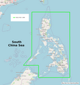 | 1,723 × 1,851 (377 KB) | Toto11zi (talk | contribs) | Added text "Map data from OpenStreetMap" |
| 14:32, 14 April 2024 | 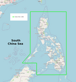 | 1,723 × 1,851 (374 KB) | Toto11zi (talk | contribs) | This is boundary of the Philippines based on Treaty of Paris (1898): Article III. Spain cedes to the United States the archipelago known as the Philippine Islands, and comprehending the islands lying within the following line: A line running from west to east along or near the twentieth parallel of north latitude, and through the middle of the navigable channel of Bachi, from the one hundred and eighteenth (118th) to the one hundred and twenty-seventh (127th) degree meridian of longitude ea... |
You cannot overwrite this file.