
File:PedraBranca-MapofMalaya-1925.jpg

PedraBranca-MapofMalaya-1925.jpg (621 × 458 pixels, file size: 90 KB, MIME type: image/jpeg)
| This is a file from the Wikimedia Commons. Information from its description page there is shown below. Commons is a freely licensed media file repository. You can help. |
Summary
| Description |
English: Detail of a map of Malaya (British Malaya) by the Surveyor General of the Federated Malay States and Straits Settlements, showing Singapore (part of the Straits Settlements) shaded in red and Johor (one of the Unfederated Malay States) in orange. The island of Pedra Branca appears on the right of the map marked "Pedra Branca Horsburgh". See Case Concerning Sovereignty over Pedra Branca/Pulau Batu Puteh, Middle Rocks and South Ledge (Malaysia/Singapore): Memorial of Malaysia, vol. 1, p. 143, para. 314. |
| Date | |
| Source | Reproduced as insert 27 of (25 March 2004) Case Concerning Sovereignty over Pedra Branca/Pulau Batu Puteh, Middle Rocks and South Ledge (Malaysia/Singapore): Memorial of Malaysia, volume 1, Government of Malaysia (reproduced on the International Court of Justice website), p. 144 Retrieved on 28 September 2008. |
| Author | Surveyor General of the Federated Malay States and Straits Settlements. |
Licensing
|
This work is in the public domain in its country of origin and other countries and areas where the copyright term is the author's life plus 70 years or fewer.
| |
| This file has been identified as being free of known restrictions under copyright law, including all related and neighboring rights. | |
File history
Click on a date/time to view the file as it appeared at that time.
| Date/Time | Thumbnail | Dimensions | User | Comment | |
|---|---|---|---|---|---|
| current | 17:32, 28 September 2008 | 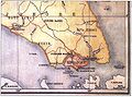 | 621 × 458 (90 KB) | Jacklee | ==Summary== {{Information |Description = {{en|Detail of a map of Malaya (British Malaya) by the Surveyor General of the Federated Malay States and Straits Settlements, showing |
File usage
Global file usage
The following other wikis use this file:
- Usage on es.wikipedia.org
- Usage on ru.wikipedia.org