
File:Papua New Guinea relief map.svg

Size of this PNG preview of this SVG file: 800 × 481 pixels. Other resolutions: 320 × 192 pixels | 640 × 385 pixels | 1,024 × 615 pixels | 1,280 × 769 pixels | 2,560 × 1,538 pixels | 2,280 × 1,370 pixels.
Original file (SVG file, nominally 2,280 × 1,370 pixels, file size: 3.51 MB)
| This is a file from the Wikimedia Commons. Information from its description page there is shown below. Commons is a freely licensed media file repository. You can help. |
Summary
| Description |
English: Elevation data from STRM30. Bathymetry from GMRT, rivers/coastline from GSHHS. |
| Date | |
| Source | Derivative of Papua New Guinea location map.svg |
| Author | Own work based on User:NordNordWest |
Licensing
This file is licensed under the Creative Commons Attribution-Share Alike 3.0 Unported license.
- You are free:
- to share – to copy, distribute and transmit the work
- to remix – to adapt the work
- Under the following conditions:
- attribution – You must give appropriate credit, provide a link to the license, and indicate if changes were made. You may do so in any reasonable manner, but not in any way that suggests the licensor endorses you or your use.
- share alike – If you remix, transform, or build upon the material, you must distribute your contributions under the same or compatible license as the original.
File history
Click on a date/time to view the file as it appeared at that time.
| Date/Time | Thumbnail | Dimensions | User | Comment | |
|---|---|---|---|---|---|
| current | 21:42, 21 November 2020 | 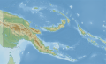 | 2,280 × 1,370 (3.51 MB) | C1MM | Uploaded a work by Own work based on User:NordNordWest from Derivative of Papua New Guinea location map.svg with UploadWizard |
File usage
More than 100 pages use this file. The following list shows the first 100 pages that use this file only. A full list is available.
- Adelbert Range
- Aphantophryne minuta
- Aphantophryne sabini
- Austrochaperina aquilonia
- Bagana
- Baining Mountains
- Baiyer River Sanctuary
- Barygenys cheesmanae
- Barygenys parvula
- Battle of Cape Gloucester
- Battle of Goodenough Island
- Bewani Mountains
- Billy Mitchell (volcano)
- Bismarck Range
- Bismarck Sea
- Bola (volcano)
- Bootless Inlet
- Callulops marmoratus
- Carteret Islands
- Chambri Lakes
- China Strait
- Choerophryne allisoni
- Choerophryne exclamitans
- Choerophryne rhenaurum
- Choerophryne sanguinopicta
- Choerophryne siegfriedi
- Cophixalus bewaniensis
- Cophixalus nubicola
- Cophixalus pulchellus
- Cophixalus tagulensis
- Cophixalus timidus
- Cornufer macrops
- Cornufer macrosceles
- Cornufer mamusiorum
- Dakataua
- Dampier Strait (Papua New Guinea)
- Emperor Range
- Finisterre Range
- Garbuna Group
- Hans Meyer Range
- Hindenburg Range
- Huon Gulf
- Kadovar
- Karkar Island
- Kikori River
- Kratke Range
- Kuk Swamp
- Lake Kutubu
- Langila
- Lassul Bay
- Loloru
- Long Island (Papua New Guinea)
- Lyra Reef
- Manam Motu
- Mantophryne louisiadensis
- Milne Bay
- Mount Albert Edward (Papua New Guinea)
- Mount Balbi
- Mount Bellamy
- Mount Bosavi
- Mount Giluwe
- Mount Hagen (volcano)
- Mount Lamington
- Mount Sarawaget
- Mount Suckling
- Mount Trafalgar
- Mount Victoria (Papua New Guinea)
- Mount Victory (Papua New Guinea)
- Mount Vineuo
- Mount Wilhelm
- No. 2 Strip Milne Bay
- Nyctimystes daymani
- Olsobip Rural LLG
- Owen Stanley Range
- Pago (Papua New Guinea)
- Port Moresby
- Prince Alexander Mountains
- Rossel Mountains
- Sakar Island
- Saruwaged Range
- Schleinitz Range
- Schrader Range
- Solomon Sea
- Sphenophryne similis
- Star Mountains
- Steffen Strait
- Takuan Group
- Tanga Islands
- Tavurvur
- Tonda Wildlife Management Area
- Tore (volcano)
- Torricelli Range
- Ulawun
- Verron Range
- Victor Emanuel Range
- Vitiaz Strait
- Waiowa
- Wanigela Airport
- Ward Hunt Strait
- YUS Conservation Area
View more links to this file.
Global file usage
The following other wikis use this file:
- Usage on ast.wikipedia.org
- Usage on bn.wikipedia.org
- Usage on hr.wikipedia.org
- Usage on ilo.wikipedia.org
- Usage on ja.wikipedia.org
- Usage on kn.wikipedia.org
- Usage on ms.wikipedia.org
- Usage on si.wikipedia.org
- Usage on ta.wikipedia.org
- Usage on uk.wikipedia.org
- Usage on uz.wikipedia.org
- Usage on www.wikidata.org