
File:Palestine Land ownership by sub-district (1945).jpg

Original file (2,038 × 3,651 pixels, file size: 2 MB, MIME type: image/jpeg)
| This is a file from the Wikimedia Commons. Information from its description page there is shown below. Commons is a freely licensed media file repository. You can help. |
Summary
| Description |
English: Palestine(1945) Land ownership by sub-district. Details in French : Division of the agricultural lands by sub-districts
United Nations Map no. 94(b), August 1950
Français : Reparatition de la propriete agraire par sous-district (1945), carte des Nations Unies, Août 1950
עברית: מפת הבעלות על הקרקע בארץ ישראל המנדטורית על פי קבוצה אתנית: יהודים, ערבים ואדמות מדינה (1945), United Nations Map no. 94(b), August 1950 |
| Date | |
| Source | United Nations UNISPAL website |
| Author | United Nations |
Licensing
| This image is a map derived from a United Nations map.
Unless stated otherwise, UN maps are to be considered in the public domain. This applies worldwide. UN maps are, in principle, open source material and you can use them in your work or for making your own map. UN requests however that you delete the UN name, logo and reference number upon any modification to the map. Content of your map will be your responsibility. You can state in your publication, if you wish, something like: based on UN map … (map name, map number, revision number and date). See: Geospatial Information Section. And: Geospatial, location data for a better world. |
 |
File history
Click on a date/time to view the file as it appeared at that time.
| Date/Time | Thumbnail | Dimensions | User | Comment | |
|---|---|---|---|---|---|
| current | 13:07, 12 August 2013 | 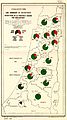 | 2,038 × 3,651 (2 MB) | Onceinawhile | User created page with UploadWizard |
File usage
Global file usage
The following other wikis use this file:
- Usage on ar.wikipedia.org
- Usage on azb.wikipedia.org
- Usage on ca.wikipedia.org
- Usage on da.wikipedia.org
- Usage on es.wikipedia.org
- Usage on fa.wikipedia.org
- Usage on ga.wikipedia.org
- Usage on he.wikipedia.org
- Usage on ja.wikipedia.org
- Usage on nl.wikipedia.org
- Usage on ru.wikipedia.org
- Usage on tr.wikipedia.org
- Usage on ur.wikipedia.org