
File:Palawan division proposal 2020.svg

Size of this PNG preview of this SVG file: 800 × 501 pixels. Other resolutions: 320 × 200 pixels | 640 × 401 pixels | 1,024 × 641 pixels | 1,280 × 801 pixels | 2,560 × 1,602 pixels | 2,980 × 1,865 pixels.
Original file (SVG file, nominally 2,980 × 1,865 pixels, file size: 404 KB)
| This is a file from the Wikimedia Commons. Information from its description page there is shown below. Commons is a freely licensed media file repository. You can help. |
Summary
| Description |
English: Proposed division of Palawan into three provinces This W3C-unspecified vector image was created with Inkscape . |
| Date | (UTC) |
| Source |
This file was derived from: PhlMapCit.svg:  |
| Author |
|
| This is a retouched picture, which means that it has been digitally altered from its original version. The original can be viewed here: PhlMapCit.svg:
|
Licensing
| This file is licensed under the Creative Commons Attribution-Share Alike 3.0 Unported license. | ||
| Attribution: Felipe Aira and Hariboneagle927 | ||
| ||
| This licensing tag was added to this file as part of the GFDL licensing update. |
Original upload log
This image is a derivative work of the following images:
- File:PhlMapCit.svg licensed with Cc-by-sa-3.0-migrated, GFDL, GFDL-user
- 2019-05-29T02:12:06Z HueMan1 4751x6104 (2417908 Bytes) Added missing borders in Lanao del Sur and Bukidnon; Fixed boundaries in Isabela, and some of Rizal and Cebu; Fixed the coastlines of Panay and Cebu Islands. (Aklan, Negros Occidental, and Maguindanao boundaries are still inc
- 2019-04-10T03:17:19Z HueMan1 4751x6104 (2762350 Bytes) Revised version. Added Davao Occidental.
- 2008-12-18T12:05:41Z Felipe Aira 4751x6104 (2602003 Bytes) iwinastong bersyon
- 2008-12-04T13:23:50Z Felipe Aira 4751x6104 (2714929 Bytes) {{Information |Description= {{tgl|1=Mga bayan at lungsod ng Pilipinas}}{{en|1=Towns and cities of the Philippines}}{{Inkscape}} |Source=Own work by uploader |Author=[[User:Felipe Aira|Felipe Aira]] |Date=Disyembre 6, 2008 |
Uploaded with derivativeFX
File history
Click on a date/time to view the file as it appeared at that time.
| Date/Time | Thumbnail | Dimensions | User | Comment | |
|---|---|---|---|---|---|
| current | 03:00, 16 March 2021 | 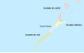 | 2,980 × 1,865 (404 KB) | HueMan1 | Standardised styling |
| 19:08, 25 December 2020 | 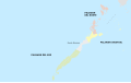 | 2,980 × 1,865 (1.58 MB) | Hariboneagle927 | P. Princesa spelling | |
| 19:01, 25 December 2020 |  | 2,980 × 1,865 (1.58 MB) | Hariboneagle927 | == {{int:filedesc}} == {{Information |Description={{en|1=Proposed division of Palawan into three provinces}}<br />{{Inkscape}} |Source={{Derived from|PhlMapCit.svg|display=50}} |Date=2020-12-25 19:01 (UTC) |Author=* File:PhlMapCit.svg: Felipe Aira * derivative work: [[User:{{subst:REVISIONUSER}}|{{subst:REVISIONUSER}}]] |Permission= |other_versions= }} {{RetouchedPicture||editor=|orig=PhlMapCit.svg}} == {{int:license-header}} == {{self|Cc-by-sa-3... |
File usage
The following pages on the English Wikipedia use this file (pages on other projects are not listed):
Global file usage
The following other wikis use this file:
- Usage on bcl.wikipedia.org
- Usage on tl.wikipedia.org