
File:Ottoman vojvodina01.png

Size of this preview: 579 × 600 pixels. Other resolutions: 232 × 240 pixels | 463 × 480 pixels | 944 × 978 pixels.
Original file (944 × 978 pixels, file size: 107 KB, MIME type: image/png)
| This is a file from the Wikimedia Commons. Information from its description page there is shown below. Commons is a freely licensed media file repository. You can help. |
Summary
| Description |
English: Historic map of the Eyalet of Temeşvar, Sanjak of Sirem, Sanjak of Segedin, and Banate of Lwgas and Karansebes.
Српски / srpski: Историјска мапа Темишварског пашалука, Сремског санџака, Сегединског санџака и Лугошког и карансебешког Баната. |
| Date | 23 March 2009 (original upload date) |
| Source | No machine-readable source provided. Own work assumed (based on copyright claims). |
| Author | No machine-readable author provided. PANONIAN assumed (based on copyright claims). |
References
- The Times History of Europe, Times Books, 2002.
- Istorijski atlas, Zavod za udžbenike i nastavna sredstva - Zavod za kartografiju "Geokarta", Beograd, 1999.
- Milan Tutorov, Banatska rapsodija - istorika Zrenjanina i Banata, Novi Sad, 2001.
- Peter Rokai - Zoltan Đere - Tibor Pal - Aleksandar Kasaš, Istorija Mađara, Beograd, 2002.
- Dr Dušan J. Popović, Srbi u Vojvodini, knjiga 1, Novi Sad, 1990.
Licensing
self made map by user:PANONIAN
| I, the copyright holder of this work, release this work into the public domain. This applies worldwide. In some countries this may not be legally possible; if so: I grant anyone the right to use this work for any purpose, without any conditions, unless such conditions are required by law. |
File history
Click on a date/time to view the file as it appeared at that time.
| Date/Time | Thumbnail | Dimensions | User | Comment | |
|---|---|---|---|---|---|
| current | 14:33, 20 April 2015 |  | 944 × 978 (107 KB) | PANONIAN | corrections |
| 08:45, 12 October 2013 | 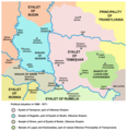 | 944 × 978 (107 KB) | PANONIAN | aesthetics | |
| 20:58, 14 September 2013 |  | 945 × 978 (107 KB) | PANONIAN | aesthetics | |
| 19:22, 5 September 2013 |  | 945 × 978 (107 KB) | PANONIAN | minor change | |
| 14:12, 31 March 2009 | 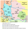 | 947 × 978 (107 KB) | PANONIAN | ||
| 22:19, 23 March 2009 |  | 947 × 978 (106 KB) | PANONIAN | historic map of the Eyalet of Temeşvar, Sanjak of Sirem, Sanjak of Segedin, and Banate of Lugos and Karansebes (self made) {{PD-self}} Category:Maps of the history of Romania Category:Maps of the history of Serbia [[Category:Maps of the history o |
File usage
The following pages on the English Wikipedia use this file (pages on other projects are not listed):
Global file usage
The following other wikis use this file:
- Usage on de.wikipedia.org
- Usage on el.wikipedia.org
- Usage on et.wikipedia.org
- Usage on fr.wikipedia.org
- Usage on gl.wikipedia.org
- Usage on he.wikipedia.org
- Usage on it.wikipedia.org
- Usage on ja.wikipedia.org
- Usage on lt.wikipedia.org
- Usage on mk.wikipedia.org
- Usage on no.wikipedia.org
- Usage on pnb.wikipedia.org
- Usage on pt.wikipedia.org
- Usage on ro.wikipedia.org
- Usage on sh.wikipedia.org
- Usage on sl.wikipedia.org
- Usage on tr.wikipedia.org
- Usage on ur.wikipedia.org
- Usage on vi.wikipedia.org