
File:Oso Landslide aerial.jpg

Size of this preview: 800 × 521 pixels. Other resolutions: 320 × 208 pixels | 640 × 417 pixels | 1,024 × 667 pixels | 1,280 × 834 pixels | 2,907 × 1,893 pixels.
Original file (2,907 × 1,893 pixels, file size: 2.08 MB, MIME type: image/jpeg)
| This is a file from the Wikimedia Commons. Information from its description page there is shown below. Commons is a freely licensed media file repository. You can help. |
Summary
| Description |
English: Oblique aerial photograph of the 2014 landslide in northwest Washington. This image shows the entire extent of the landslide source area and path. This event is commonly named the “Oso Landslide” in many official reports. It is also referred to as the “SR530 Landslide,” as named by Snohomish County and Washington State. Credit: Mark Reid, USGS |
| Date | |
| Source | https://www.usgs.gov/media/images/2014-landslide-washington-state-7 |
| Author | Mark Reid, USGS |
Licensing
This image is in the public domain in the United States because it only contains materials that originally came from the United States Geological Survey, an agency of the United States Department of the Interior. For more information, see the official USGS copyright policy.
|
File history
Click on a date/time to view the file as it appeared at that time.
| Date/Time | Thumbnail | Dimensions | User | Comment | |
|---|---|---|---|---|---|
| current | 05:18, 14 July 2022 | 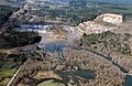 | 2,907 × 1,893 (2.08 MB) | Ron Clausen | Uploaded a work by Mark Reid, USGS from https://www.usgs.gov/media/images/2014-landslide-washington-state-7 with UploadWizard |
File usage
The following pages on the English Wikipedia use this file (pages on other projects are not listed):