
File:Operation 1027.svg
Size of this PNG preview of this SVG file: 500 × 376 pixels. Other resolutions: 319 × 240 pixels | 638 × 480 pixels | 1,021 × 768 pixels | 1,280 × 963 pixels | 2,560 × 1,925 pixels.
Original file (SVG file, nominally 500 × 376 pixels, file size: 1.64 MB)
| This is a file from the Wikimedia Commons. Information from its description page there is shown below. Commons is a freely licensed media file repository. You can help. |
Summary

|
This file may be updated to reflect new information. If you wish to use a specific version of the file without new updates being mirrored, please upload the required version as a separate file. |
This vector image was created with Inkscape.
| Description |
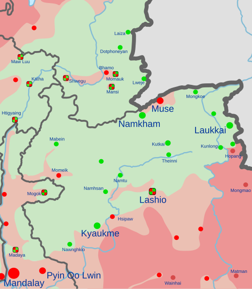
English: Map of Operation 1027.
and allies
In the respective colours: |
||
| Date | (first version) | ||
| Source |
Own work, derived from ACLED data and en:Template:Myanmar Civil War detailed map.
|
||
| Author | Clyde H. Mapping |
Licensing
I, the copyright holder of this work, hereby publish it under the following license:
This file is licensed under the Creative Commons Attribution-Share Alike 4.0 International license.
- You are free:
- to share – to copy, distribute and transmit the work
- to remix – to adapt the work
- Under the following conditions:
- attribution – You must give appropriate credit, provide a link to the license, and indicate if changes were made. You may do so in any reasonable manner, but not in any way that suggests the licensor endorses you or your use.
- share alike – If you remix, transform, or build upon the material, you must distribute your contributions under the same or compatible license as the original.
File history
Click on a date/time to view the file as it appeared at that time.
| Date/Time | Thumbnail | Dimensions | User | Comment | |
|---|---|---|---|---|---|
| current | 13:59, 19 March 2024 |  | 500 × 376 (1.64 MB) | Clyde H. Mapping | Per talk page |
| 22:19, 7 March 2024 |  | 500 × 376 (1.64 MB) | Clyde H. Mapping | Updated per template | |
| 02:00, 9 January 2024 |  | 500 × 376 (1.65 MB) | Clyde H. Mapping | Updated Kutkai, Hsenwi, Kyaukme, Momeik, and Kalewa per template | |
| 21:34, 5 January 2024 |  | 500 × 376 (1.65 MB) | Clyde H. Mapping | Updated Laukkai and Hopang per template | |
| 03:56, 4 January 2024 |  | 500 × 376 (1.65 MB) | Clyde H. Mapping | Major update based on new source (Template:Myanmar Civil War detailed map) | |
| 12:04, 15 December 2023 |  | 500 × 376 (1.5 MB) | Clyde H. Mapping | Corrected Laukkai location, added Konkyan | |
| 03:10, 18 November 2023 |  | 500 × 376 (1.49 MB) | Clyde H. Mapping | Improved pattern for contested areas | |
| 12:09, 16 November 2023 |  | 500 × 376 (1.48 MB) | Clyde H. Mapping | Updated rebel presence (TBA, KIA) in Shan and Sagaing | |
| 22:17, 12 November 2023 |  | 500 × 376 (1.48 MB) | Clyde H. Mapping | Added Hsipaw | |
| 04:09, 9 November 2023 | 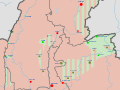 | 500 × 376 (1.47 MB) | Clyde H. Mapping | Corrected Hseni and Kunlong |
File usage
The following pages on the English Wikipedia use this file (pages on other projects are not listed):
Global file usage
The following other wikis use this file:
- Usage on fa.wikipedia.org
- Usage on fr.wikipedia.org
- Usage on ko.wikipedia.org
- Usage on mnw.wikipedia.org
- Usage on ms.wikipedia.org
- Usage on my.wikipedia.org
- Usage on ru.wikipedia.org
- Usage on uk.wikipedia.org
- Usage on zh.wikipedia.org