
File:On the Chain Briggie - geograph.org.uk - 1446552.jpg
No higher resolution available.
On_the_Chain_Briggie_-_geograph.org.uk_-_1446552.jpg (640 × 480 pixels, file size: 109 KB, MIME type: image/jpeg)
| This is a file from the Wikimedia Commons. Information from its description page there is shown below. Commons is a freely licensed media file repository. You can help. |
| This image appeared on Wikipedia's Main Page in the Did you know? column on 27 November 2013 (see archives). |
Summary
|
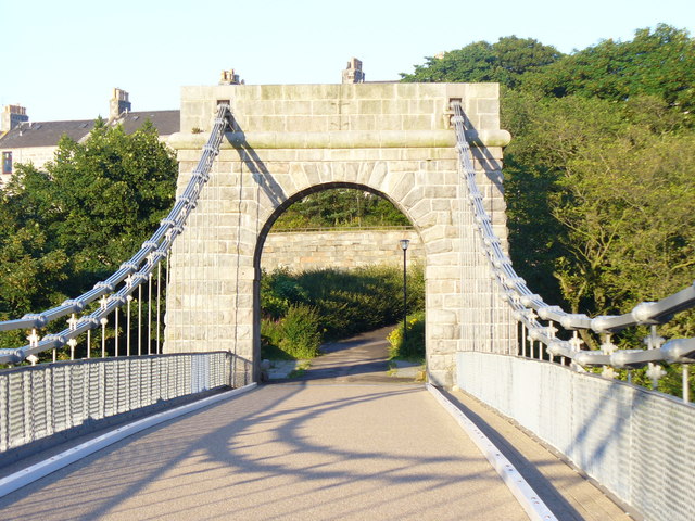
This is a photo of listed building number 20073. |
| Description |
English: On the Chain Briggie The Wellington Suspension Bridge was built in 1830 and helped the development of the fishing village, Torry, on the Kincardineshire bank of the Dee. Today, the bridge only carries pedestrian traffic. |
| Date | |
| Source | From geograph.org.uk |
| Author | Colin Smith |
| Attribution (required by the license) | Colin Smith / On the Chain Briggie / |
| Camera location | | View this and other nearby images on: OpenStreetMap |
|---|
| Object location | | View this and other nearby images on: OpenStreetMap |
|---|
Licensing

|
This image was taken from the Geograph project collection. See this photograph's page on the Geograph website for the photographer's contact details. The copyright on this image is owned by Colin Smith and is licensed for reuse under the Creative Commons Attribution-ShareAlike 2.0 license.
|
This file is licensed under the Creative Commons Attribution-Share Alike 2.0 Generic license.
Attribution: Colin Smith
- You are free:
- to share – to copy, distribute and transmit the work
- to remix – to adapt the work
- Under the following conditions:
- attribution – You must give appropriate credit, provide a link to the license, and indicate if changes were made. You may do so in any reasonable manner, but not in any way that suggests the licensor endorses you or your use.
- share alike – If you remix, transform, or build upon the material, you must distribute your contributions under the same or compatible license as the original.
File history
Click on a date/time to view the file as it appeared at that time.
| Date/Time | Thumbnail | Dimensions | User | Comment | |
|---|---|---|---|---|---|
| current | 02:40, 2 March 2011 |  | 640 × 480 (109 KB) | GeographBot | == {{int:filedesc}} == {{Information |description={{en|1=On the Chain Briggie The Wellington Suspension Bridge was built in 1830 and helped the development of the fishing village, Torry, on the Kincardineshire bank of the Dee. Today, the bridge only carri |
File usage
The following pages on the English Wikipedia use this file (pages on other projects are not listed):