
File:OSM Fortismere School site plan.png

Size of this preview: 633 × 600 pixels. Other resolutions: 253 × 240 pixels | 506 × 480 pixels | 919 × 871 pixels.
Original file (919 × 871 pixels, file size: 235 KB, MIME type: image/png)
| This is a file from the Wikimedia Commons. Information from its description page there is shown below. Commons is a freely licensed media file repository. You can help. |
Summary
| Description |
English: Site of Fortismere School in Muswell Hill, and other schools in the neighbourhood. Deutsch: Umgebung der Nord-londoner Gesamtchule: Fortismere
This map was created from OpenStreetMap project data, collected by the community.This map may be incomplete, and may contain errors. Don't rely solely on it for navigation. |
| Date | |
| Source |
Deutsch: Eigene Arbeit, basierend auf English: Own work, based on
|
| Author |
|
| Permission (Reusing this file) |
OpenStreetMap data and maps are Creative Commons "CC-BY-SA 2.0" licensed This file is licensed under the Creative Commons Attribution-Share Alike 2.0 Generic license.
|
| Camera location | | View this and other nearby images on: OpenStreetMap |
|---|
Licensing
OpenStreetMap data and maps are Creative Commons "CC-BY-SA 2.0" licensed
This file is licensed under the Creative Commons Attribution-Share Alike 2.0 Generic license.
- You are free:
- to share – to copy, distribute and transmit the work
- to remix – to adapt the work
- Under the following conditions:
- attribution – You must give appropriate credit, provide a link to the license, and indicate if changes were made. You may do so in any reasonable manner, but not in any way that suggests the licensor endorses you or your use.
- share alike – If you remix, transform, or build upon the material, you must distribute your contributions under the same or compatible license as the original.
: additions
This file is licensed under the Creative Commons Attribution-Share Alike 4.0 International license.
- You are free:
- to share – to copy, distribute and transmit the work
- to remix – to adapt the work
- Under the following conditions:
- attribution – You must give appropriate credit, provide a link to the license, and indicate if changes were made. You may do so in any reasonable manner, but not in any way that suggests the licensor endorses you or your use.
- share alike – If you remix, transform, or build upon the material, you must distribute your contributions under the same or compatible license as the original.
File history
Click on a date/time to view the file as it appeared at that time.
| Date/Time | Thumbnail | Dimensions | User | Comment | |
|---|---|---|---|---|---|
| current | 17:45, 11 September 2021 | 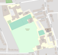 | 919 × 871 (235 KB) | Isochrone | Update, from https://www.openstreetmap.org/#map=17/51.59352/-0.15445 |
| 12:27, 18 November 2017 |  | 632 × 632 (138 KB) | ClemRutter | cropped | |
| 11:55, 18 November 2017 |  | 794 × 1,123 (271 KB) | ClemRutter | Text added | |
| 10:51, 18 November 2017 |  | 425 × 444 (104 KB) | ClemRutter | User created page with UploadWizard |
File usage
The following pages on the English Wikipedia use this file (pages on other projects are not listed):