
File:Nouveau plan de Paris, 1871 - UWM Libraries.jpg

Size of this preview: 766 × 600 pixels. Other resolutions: 307 × 240 pixels | 613 × 480 pixels | 981 × 768 pixels | 1,280 × 1,002 pixels | 2,560 × 2,005 pixels | 10,128 × 7,932 pixels.
Original file (10,128 × 7,932 pixels, file size: 17.56 MB, MIME type: image/jpeg)
| This is a file from the Wikimedia Commons. Information from its description page there is shown below. Commons is a freely licensed media file repository. You can help. |
Summary
| Warning | The original file is very high-resolution. It might not load properly or could cause your browser to freeze when opened at full size. |
|---|
| Description |
Nouveau plan de Paris, 1871 / Lanee, Editeur-Geographie ; grave par Erhard-Sehieble |
| Source | University of Wisconsin-Milwaukee Libraries |
| Creator |
Lanée |
| Georeferencing | If inappropriate please set warp_status = skip to hide. |
| Bibliographic data | |
| Publisher |
Lanée |
| Archival data | |
| Medium | map : hand-col., dissected, mounted on linen, encapsulated in Mylar ; 60 x 84 cm., on sheet 68 x 86 cm. + 1 index book (40 p. ; 18 cm.) |
| Notes |
Accompanying index book includes "Nomenclature des rues du nouveau plan" and "Itinéraire des omnibus." "Acquired by gift. Feb. 5, 1947" -- stamped in upper left margin ; "American Antiquarian Society" -- written in black ink in upper left margin. |
Licensing
|
This work is in the public domain in its country of origin and other countries and areas where the copyright term is the author's life plus 100 years or fewer. | |
| This file has been identified as being free of known restrictions under copyright law, including all related and neighboring rights. | |
File history
Click on a date/time to view the file as it appeared at that time.
| Date/Time | Thumbnail | Dimensions | User | Comment | |
|---|---|---|---|---|---|
| current | 04:59, 30 July 2020 | 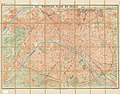 | 10,128 × 7,932 (17.56 MB) | Paris 16 | Uploaded own work with UploadWizard |
File usage
The following pages on the English Wikipedia use this file (pages on other projects are not listed):
Global file usage
The following other wikis use this file:
- Usage on es.wikipedia.org