
File:Nord Stream gas leaks 2022.svg

Size of this PNG preview of this SVG file: 512 × 343 pixels. Other resolutions: 320 × 214 pixels | 640 × 429 pixels | 1,024 × 686 pixels | 1,280 × 858 pixels | 2,560 × 1,715 pixels.
Original file (SVG file, nominally 512 × 343 pixels, file size: 424 KB)
| This is a file from the Wikimedia Commons. Information from its description page there is shown below. Commons is a freely licensed media file repository. You can help. |
Summary
| Description |
Deutsch: Karte der Explosionen, die an den Nord-Stream-Pipelines am 26. September 2022 verursacht wurden. |
| Date | |
| Source |
Own work |
| Author | FactsWithoutBias1 |
| SVG development |


Licensing
I, the copyright holder of this work, hereby publish it under the following license:
This file is licensed under the Creative Commons Attribution-Share Alike 4.0 International license.
- You are free:
- to share – to copy, distribute and transmit the work
- to remix – to adapt the work
- Under the following conditions:
- attribution – You must give appropriate credit, provide a link to the license, and indicate if changes were made. You may do so in any reasonable manner, but not in any way that suggests the licensor endorses you or your use.
- share alike – If you remix, transform, or build upon the material, you must distribute your contributions under the same or compatible license as the original.
File history
Click on a date/time to view the file as it appeared at that time.
| Date/Time | Thumbnail | Dimensions | User | Comment | |
|---|---|---|---|---|---|
| current | 13:49, 6 October 2022 | 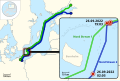 | 512 × 343 (424 KB) | FactsWithoutBias1 | added map in corner, labeled territorial sea, split pipes |
| 19:57, 5 October 2022 |  | 512 × 343 (157 KB) | FactsWithoutBias1 | zoomed in | |
| 17:38, 5 October 2022 |  | 512 × 349 (309 KB) | FactsWithoutBias1 | added 12-mile zone | |
| 15:01, 5 October 2022 |  | 512 × 349 (308 KB) | FactsWithoutBias1 | Uploaded own work with UploadWizard |
File usage
The following pages on the English Wikipedia use this file (pages on other projects are not listed):
Global file usage
The following other wikis use this file:
- Usage on cs.wikipedia.org
- Usage on da.wikipedia.org
- Usage on de.wikipedia.org
- Usage on el.wikipedia.org
- Usage on es.wikipedia.org
- Usage on fr.wikipedia.org
- Usage on ja.wikipedia.org
- Usage on ko.wikipedia.org
- Usage on ru.wikipedia.org
- Usage on simple.wikipedia.org
- Usage on sl.wikipedia.org