
File:NigerDeltaInsurgency.png

No higher resolution available.
NigerDeltaInsurgency.png (410 × 470 pixels, file size: 177 KB, MIME type: image/png)
| This is a file from the Wikimedia Commons. Information from its description page there is shown below. Commons is a freely licensed media file repository. You can help. |
Summary
| Description | Map of Southeast Nigeria conflict |
| Date | |
| Source | Own work, incidents are based on ACLED database from 29 September 2022 until 29 September 2023. For yellow I chose the interaction category 10: "Military vs rebels", for blue categories 20-28 (rebels without government), for red I chose categories 10-11, 15-17 (military without rebels) |
| Author | User:Borysk5 |
Licensing
I, the copyright holder of this work, hereby publish it under the following licenses:

|
Permission is granted to copy, distribute and/or modify this document under the terms of the GNU Free Documentation License, Version 1.2 or any later version published by the Free Software Foundation; with no Invariant Sections, no Front-Cover Texts, and no Back-Cover Texts. A copy of the license is included in the section entitled GNU Free Documentation License. |
This file is licensed under the Creative Commons Attribution-Share Alike 4.0 International license.
- You are free:
- to share – to copy, distribute and transmit the work
- to remix – to adapt the work
- Under the following conditions:
- attribution – You must give appropriate credit, provide a link to the license, and indicate if changes were made. You may do so in any reasonable manner, but not in any way that suggests the licensor endorses you or your use.
- share alike – If you remix, transform, or build upon the material, you must distribute your contributions under the same or compatible license as the original.
You may select the license of your choice.
| Description |
This map was created from OpenStreetMap project data, collected by the community. This map may be incomplete, and may contain errors. Don't rely solely on it for navigation. |
|||
| Date | (see file history) | |||
| Source | openstreetmap.org | |||
| Creator |
OpenStreetMap contributors |
|||
| Permission (Reusing this file) |
OpenStreetMap data is available under the Open Database License (details). Map tiles are licensed under the Creative Commons Attribution-ShareAlike 2.0 license (CC-BY-SA 2.0).
This file is licensed under the Creative Commons Attribution-Share Alike 2.0 Generic license.
|
|||
| Georeferencing | If inappropriate please set warp_status = skip to hide. |
File history
Click on a date/time to view the file as it appeared at that time.
| Date/Time | Thumbnail | Dimensions | User | Comment | |
|---|---|---|---|---|---|
| current | 12:22, 8 October 2023 | 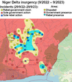 | 410 × 470 (177 KB) | Borysk5 | == {{int:filedesc}} == {{Information |Description=Map of West Papua conflict |Source={{own}}, incidents are based on ACLED database from 29 September 2022 until 29 September 2023. For yellow I chose the interaction category 10: "Military vs rebels", for blue categories 20-28 (rebels without government), for red I chose categories 10-11, 15-17 (military without rebels) |Date=2023-10-08 |Author=User:Borysk5 |Permission= |other_versions= }} Category:Maps of civil wars == {{int:license-he... |
File usage
The following pages on the English Wikipedia use this file (pages on other projects are not listed):