
File:New haven line map.png

Size of this preview: 800 × 565 pixels. Other resolutions: 320 × 226 pixels | 640 × 452 pixels | 1,024 × 724 pixels | 1,280 × 905 pixels | 2,640 × 1,866 pixels.
Original file (2,640 × 1,866 pixels, file size: 1.84 MB, MIME type: image/png)
| This is a file from the Wikimedia Commons. Information from its description page there is shown below. Commons is a freely licensed media file repository. You can help. |
| Description |
English: Map of New Haven Line |
|||||||||
| Date | ||||||||||
| Source |
Map was created by using
|
|||||||||
| Creator |
|
|||||||||
| Geotemporal data | ||||||||||
| Bounding box |
|
|||||||||
| Georeferencing | ||||||||||
I, the copyright holder of this work, hereby publish it under the following license:
This file is licensed under the Creative Commons Attribution 3.0 Unported license.
- You are free:
- to share – to copy, distribute and transmit the work
- to remix – to adapt the work
- Under the following conditions:
- attribution – You must give appropriate credit, provide a link to the license, and indicate if changes were made. You may do so in any reasonable manner, but not in any way that suggests the licensor endorses you or your use.
| This work is licensed under the Open Database License (summary). |
File history
Click on a date/time to view the file as it appeared at that time.
| Date/Time | Thumbnail | Dimensions | User | Comment | |
|---|---|---|---|---|---|
| current | 17:31, 3 November 2016 | 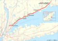 | 2,640 × 1,866 (1.84 MB) | Pechristener | state borders added |
| 16:21, 3 November 2016 |  | 2,640 × 1,866 (1.78 MB) | Pechristener | {{Map |Description={{en|1=Map of New Haven Line}} |Source=Map was created by using * [http://www.openstreetmap.org/ Open Street Map] Data * Usa edcp location map.svg (for location map) |Author= * rendering with Mape... |
File usage
The following pages on the English Wikipedia use this file (pages on other projects are not listed):
Global file usage
The following other wikis use this file:
- Usage on de.wikipedia.org
- Usage on nl.wikipedia.org
- Usage on www.wikidata.org