
File:New England (1).jpg
Size of this preview: 691 × 599 pixels. Other resolutions: 277 × 240 pixels | 553 × 480 pixels | 885 × 768 pixels | 1,180 × 1,024 pixels | 2,000 × 1,735 pixels.
Original file (2,000 × 1,735 pixels, file size: 3.5 MB, MIME type: image/jpeg)
| This is a file from the Wikimedia Commons. Information from its description page there is shown below. Commons is a freely licensed media file repository. You can help. |
Summary
| Description |
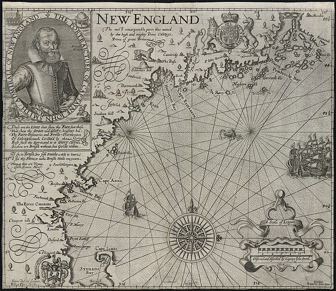
Zoom into this map at maps.bpl.org. Author: Smith, John Publisher: Printed by Geor. Low Date: [1624] Location: New England Scale: Scale [ca. 1:1,120,000] Call Number: G3720 1624.S6 Based on John Smiths 1614 voyage along the New England coast, this is the first printed map devoted specifically to this region. It is also the first to use the name “New England”for an area that had up until this time been called “North Virginia.”Smith, who is more commonly associated with the founding of Virginia, was commissioned to survey the coastline north of New York in preparation for the settlement of another English colony. This map was used to guide the Pilgrims to Plymouth and also led John Winthrop to the Charles River in 1629. |
| Date | |
| Source |
|
| Author | http://maps.bpl.org |
Licensing
This file is licensed under the Creative Commons Attribution 2.0 Generic license.
- You are free:
- to share – to copy, distribute and transmit the work
- to remix – to adapt the work
- Under the following conditions:
- attribution – You must give appropriate credit, provide a link to the license, and indicate if changes were made. You may do so in any reasonable manner, but not in any way that suggests the licensor endorses you or your use.
| This image, originally posted to Flickr, was reviewed on December 30, 2011 by the administrator or reviewer File Upload Bot (Magnus Manske), who confirmed that it was available on Flickr under the stated license on that date. |
File history
Click on a date/time to view the file as it appeared at that time.
| Date/Time | Thumbnail | Dimensions | User | Comment | |
|---|---|---|---|---|---|
| current | 20:10, 30 December 2011 |  | 2,000 × 1,735 (3.5 MB) | File Upload Bot (Magnus Manske) | {{Information |Description=Zoom into [http://maps.bpl.org/id/10050 this map] at [http://maps.bpl.org maps.bpl.org]. '''Author:''' Smith, John '''Publisher:''' Printed by Geor. Low '''Date:''' [1624] '''Location:''' New England '''Scale:''' Scale [ca. 1:1 |
File usage
The following pages on the English Wikipedia use this file (pages on other projects are not listed):
Global file usage
The following other wikis use this file:
- Usage on eo.wikipedia.org