
File:Nemegtomaia maps.png
Size of this preview: 800 × 407 pixels. Other resolutions: 320 × 163 pixels | 640 × 326 pixels | 1,024 × 521 pixels | 1,280 × 651 pixels | 3,397 × 1,729 pixels.
Original file (3,397 × 1,729 pixels, file size: 4.66 MB, MIME type: image/png)
| This is a file from the Wikimedia Commons. Information from its description page there is shown below. Commons is a freely licensed media file repository. You can help. |
Summary
| Description |
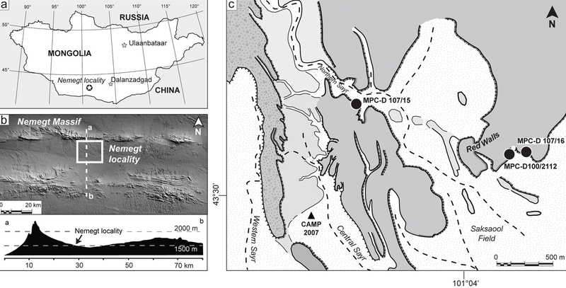
The Nemegt locality the Gobi Desert, southern Mongolia. A, map showing the location of the study area within southern Mongolia; B, the Nemegt area is located a few kilometers south of the massif of the same name; C, a detail of the Nemegt locality (sensu 5), showing the exact locations of Nemegtomaia specimens described in this study. |
| Date | |
| Source | http://www.plosone.org/article/info%3Adoi%2F10.1371%2Fjournal.pone.0031330 |
| Author | Federico Fanti, Philip J. Currie, Demchig Badamgarav |
Licensing
|
This file is licensed under the Creative Commons Attribution 2.5 Generic license.
|
This file was published in a Public Library of Science journal. Their website states that the content of all PLOS journals is published under the Creative Commons Attribution 4.0 license (or its previous version depending on the publication date), unless indicated otherwise.
|
This file, which was originally posted to
http://www.plosone.org/article/info%3Adoi%2F10.1371%2Fjournal.pone.0031330, was reviewed on 30 March 2016 by reviewer Dyolf77, who confirmed that it was available there under the stated license on that date.
|
File history
Click on a date/time to view the file as it appeared at that time.
| Date/Time | Thumbnail | Dimensions | User | Comment | |
|---|---|---|---|---|---|
| current | 21:53, 24 October 2018 |  | 3,397 × 1,729 (4.66 MB) | FunkMonk | Cropped 1 % horizontally, 1 % vertically using CropTool with precise mode. |
| 22:35, 8 September 2016 |  | 3,446 × 1,753 (4.72 MB) | FunkMonk | == {{int:filedesc}} == {{Information |Description=The Nemegt locality the Gobi Desert, southern Mongolia. A, map showing the location of the study area within southern Mongolia; B, the Nemegt area is located a few kilometers south of the massif of the... |
File usage
The following pages on the English Wikipedia use this file (pages on other projects are not listed):
Global file usage
The following other wikis use this file:
- Usage on de.wikipedia.org
- Usage on es.wikipedia.org
- Usage on fa.wikipedia.org
- Usage on nl.wikipedia.org
- Usage on pl.wikipedia.org
- Usage on zh.wikipedia.org