
File:Near Mestia, Svan towers (35252565354).jpg
Original file (5,184 × 3,456 pixels, file size: 9.69 MB, MIME type: image/jpeg)
| This is a file from the Wikimedia Commons. Information from its description page there is shown below. Commons is a freely licensed media file repository. You can help. |
Summary
| Description |
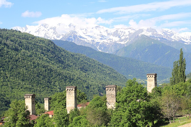
Mestia is a highland townlet in northwest Georgia, at an elevation of 1,500 metres in the Caucasus Mountains. Mestia is located in the Svaneti region of Samegrelo-Zemo Svaneti province. Mestia and the adjoining 132 villages form Mestia District (raioni). Its area is 30,444 square kilometres and its population is 14,248 (2,600 in the town itself), according to the 2002 Georgia census. It was granted the status of a townlet (Georgian: daba) in 1968. Historically and ethnographically, Mestia has always been regarded a chief community of Zemo, or Upper Svaneti province. The population is mostly Svans, a cultural and linguistic subgroup of the Georgians. Despite its small size, the townlet was an important centre of Georgian culture for centuries and contains a number of medieval monuments, such as churches and forts, included in a list of UNESCO World Heritage Sites. The townlet is dominated by stone defensive towers of a type seen in Ushguli ("Svan towers"). A typical Svan fortified dwelling consisted of a tower, an adjacent house (machub) and some other household structures encircled by a defensive wall. (source: <aexternal free">https://en.wikipedia.org/wiki/Mestia" rel="nofollow">en.wikipedia.org/wiki/Mestia</a>) |
| Date | |
| Source | Near Mestia, Svan towers |
| Author | Arian Zwegers from Brussels, Belgium |
| Camera location | | View this and other nearby images on: OpenStreetMap |
|---|
Licensing
- You are free:
- to share – to copy, distribute and transmit the work
- to remix – to adapt the work
- Under the following conditions:
- attribution – You must give appropriate credit, provide a link to the license, and indicate if changes were made. You may do so in any reasonable manner, but not in any way that suggests the licensor endorses you or your use.
| This image was originally posted to Flickr by Arian Zwegers at https://flickr.com/photos/67769030@N07/35252565354 (archive). It was reviewed on 4 November 2018 by FlickreviewR 2 and was confirmed to be licensed under the terms of the cc-by-2.0. |
File history
Click on a date/time to view the file as it appeared at that time.
| Date/Time | Thumbnail | Dimensions | User | Comment | |
|---|---|---|---|---|---|
| current | 07:51, 4 November 2018 |  | 5,184 × 3,456 (9.69 MB) | Kober | Transferred from Flickr via #flickr2commons |
File usage
Global file usage
The following other wikis use this file:
- Usage on mt.wikipedia.org
- Usage on ru.wikipedia.org