
File:Napoleonic northern Italy circa 1795–1801.jpg
Size of this preview: 800 × 590 pixels. Other resolutions: 320 × 236 pixels | 640 × 472 pixels | 861 × 635 pixels.
Original file (861 × 635 pixels, file size: 196 KB, MIME type: image/jpeg)
| This is a file from the Wikimedia Commons. Information from its description page there is shown below. Commons is a freely licensed media file repository. You can help. |
Summary
| Description |
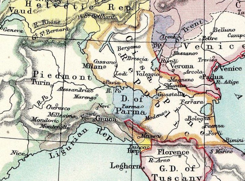
English: Plate 11. Two maps of central Europe amid the Napoleonic Wars.
Left map: "Central Europe from the Peace of Basle (April 1795) to the War of the 2nd Coalition (1799–1801)" Abp. ..... Archbishopric A.C. ......... Lands of the Archchancellor Bp. ..... Bishopric D. ..... Duchy El. ..... Electorate G.D. ..... Grand Duchy I.T. ......... Imperial town K. ..... Kingdom Lg. ..... Landgraviate M. ..... Margraviate N.O. ......... Nassau-Orange R. or Rep. ..... Republic |
| Date | |
| Source | Historical Atlas of Modern Europe |
| Author | Reginald Lane Poole |
| Other versions |
|


Licensing
|
This work is in the public domain in its country of origin and other countries and areas where the copyright term is the author's life plus 70 years or fewer. This work is in the public domain in the United States because it was published (or registered with the U.S. Copyright Office) before January 1, 1929. | |
| This file has been identified as being free of known restrictions under copyright law, including all related and neighboring rights. | |
File history
Click on a date/time to view the file as it appeared at that time.
| Date/Time | Thumbnail | Dimensions | User | Comment | |
|---|---|---|---|---|---|
| current | 01:35, 23 February 2022 |  | 861 × 635 (196 KB) | Nederlandse Leeuw | File:Napoleonic Central Europe.jpg cropped 78 % horizontally, 78 % vertically using CropTool with precise mode. |
File usage
The following pages on the English Wikipedia use this file (pages on other projects are not listed):