
File:NEXRAD loop of the Rolling Fork EF4 tornado.gif

Size of this preview: 800 × 444 pixels. Other resolutions: 320 × 178 pixels | 640 × 355 pixels | 1,127 × 626 pixels.
Original file (1,127 × 626 pixels, file size: 6.37 MB, MIME type: image/gif, looped, 39 frames, 15 s)
| This is a file from the Wikimedia Commons. Information from its description page there is shown below. Commons is a freely licensed media file repository. You can help. |
Summary
| Description |
English: A NEXRAD radar loop of the Rolling Fork EF4 tornado on March 24, 2023. The tornado peaked in intensity while striking Rolling Fork, with winds estimated at 195 miles per hour (314 km/h). Thumbs are:
|
| Date | |
| Source | NEXRAD KDGX accessed via GR2Analyst |
| Author | National Weather Service |
Licensing
This image is in the public domain because it is from one or more of the U.S. government’s 159 NEXRAD radars, which are jointly owned and operated by the National Weather Service (NWS), an agency of the National Oceanic and Atmospheric Administration (NOAA) within the United States Department of Commerce, the Federal Aviation Administration (FAA) within the Department of Transportation, and the U.S. Air Force within the Department of Defense.
Thus all NEXRAD images are public domain.
|
  |
File history
Click on a date/time to view the file as it appeared at that time.
| Date/Time | Thumbnail | Dimensions | User | Comment | |
|---|---|---|---|---|---|
| current | 17:44, 2 April 2023 |  | 1,127 × 626 (6.37 MB) | WeatherWriter | Only the EF4 tornado here |
| 17:10, 2 April 2023 | 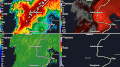 | 1,127 × 626 (9.65 MB) | WeatherWriter | Uploaded a work by National Weather Service from NEXRAD accessed via GR2Analyst with UploadWizard |
File usage
The following pages on the English Wikipedia use this file (pages on other projects are not listed):