
File:NCbarrierislandsmap.png

Size of this preview: 369 × 599 pixels. Other resolutions: 148 × 240 pixels | 472 × 766 pixels.
Original file (472 × 766 pixels, file size: 17 KB, MIME type: image/png)
| This is a file from the Wikimedia Commons. Information from its description page there is shown below. Commons is a freely licensed media file repository. You can help. |

|
This map image could be re-created using vector graphics as an SVG file. This has several advantages; see Commons:Media for cleanup for more information. If an SVG form of this image is available, please upload it and afterwards replace this template with
{{vector version available|new image name}}.
It is recommended to name the SVG file “NCbarrierislandsmap.svg”—then the template Vector version available (or Vva) does not need the new image name parameter. |
Summary
| Description |
English: A map of NC's barrier islands |
| Date | |
| Source | Own work by uploader modified from this NOAA file (archived from the original). |
| Author | Yohmom |
| Permission (Reusing this file) |
NOAA files are public domain and see below for further permission. |
Licensing
I, the copyright holder of this work, hereby publish it under the following license:
This file is licensed under the Creative Commons Attribution 3.0 Unported license.
- You are free:
- to share – to copy, distribute and transmit the work
- to remix – to adapt the work
- Under the following conditions:
- attribution – You must give appropriate credit, provide a link to the license, and indicate if changes were made. You may do so in any reasonable manner, but not in any way that suggests the licensor endorses you or your use.
File history
Click on a date/time to view the file as it appeared at that time.
| Date/Time | Thumbnail | Dimensions | User | Comment | |
|---|---|---|---|---|---|
| current | 03:47, 25 February 2009 |  | 472 × 766 (17 KB) | Yohmom | really labeled currituck this time... |
| 03:46, 25 February 2009 | 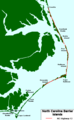 | 472 × 766 (17 KB) | Yohmom | labeled Currituck | |
| 19:54, 14 February 2009 |  | 472 × 766 (17 KB) | Yohmom | {{Information |Description={{en|1=A map of NC's barrier islands}} |Source=Own work by uploader |Author=Yohmom |Date=2008-02-13 |Permission= |other_versions= }} <!--{{ImageUpload|full}}--> Category:North Carolina [[Category:Islands by |
File usage
The following pages on the English Wikipedia use this file (pages on other projects are not listed):
Global file usage
The following other wikis use this file:
- Usage on fr.wikipedia.org
- Usage on zh.wikipedia.org