
File:Municipios de Yucatan con regiones.svg

Size of this PNG preview of this SVG file: 751 × 496 pixels. Other resolutions: 320 × 211 pixels | 640 × 423 pixels | 1,024 × 676 pixels | 1,280 × 845 pixels | 2,560 × 1,691 pixels.
Original file (SVG file, nominally 751 × 496 pixels, file size: 84 KB)
| This is a file from the Wikimedia Commons. Information from its description page there is shown below. Commons is a freely licensed media file repository. You can help. |
| Description |
Español: Mapa de los municipios del estado de Yucatán, México (con regiones).
English: Map of the Municipalities of the State of Yucatán, México (with regions). |
| Date | (UTC) |
| Source | Tizimin_en_Yucatan.svg |
| Author |
Tizimin_en_Yucatan.svg: Battroid
|
| This is a retouched picture, which means that it has been digitally altered from its original version. Modifications: Fixed duplicate code INEGI 104 (now INEGI 105). Moved INEGI 016 to correct location and made INEGI 073 the correct shape. Color coded regions.. The original can be viewed here: Tizimin en Yucatan.svg:
|
I, the copyright holder of this work, hereby publish it under the following license:
This file is licensed under the Creative Commons Attribution-Share Alike 2.5 Generic license.
- You are free:
- to share – to copy, distribute and transmit the work
- to remix – to adapt the work
- Under the following conditions:
- attribution – You must give appropriate credit, provide a link to the license, and indicate if changes were made. You may do so in any reasonable manner, but not in any way that suggests the licensor endorses you or your use.
- share alike – If you remix, transform, or build upon the material, you must distribute your contributions under the same or compatible license as the original.
Uploaded with derivativeFX
File history
Click on a date/time to view the file as it appeared at that time.
| Date/Time | Thumbnail | Dimensions | User | Comment | |
|---|---|---|---|---|---|
| current | 22:13, 21 May 2010 |  | 751 × 496 (84 KB) | Addicted04 | Reverted, conflict with the english wikipedia |
| 23:17, 20 May 2010 |  | 1,000 × 800 (175 KB) | Addicted04 | new map | |
| 21:32, 18 November 2009 |  | 751 × 496 (84 KB) | Holmes Mike | text location correction and 104 refix | |
| 21:30, 18 November 2009 |  | 751 × 496 (84 KB) | Holmes Mike | Text position and 104 recorrection after font change | |
| 21:08, 18 November 2009 | 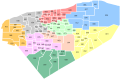 | 751 × 496 (84 KB) | Holmes Mike | changed fonts | |
| 20:58, 18 November 2009 |  | 751 × 496 (32 KB) | Holmes Mike | Changed fonts | |
| 20:43, 18 November 2009 |  | 751 × 496 (31 KB) | Holmes Mike | {{Information |Description=*{{es icon}} Mapa de los municipios del estado de Yucatán, México (con las regiónes). *{{en icon}} Map of the Municipalities of the State of Yucatán, México (with regions). |Source=*[[:File:Municipios_de_Yucatan_con_regi | |
| 20:21, 18 November 2009 |  | 751 × 496 (32 KB) | Holmes Mike | {{Information |Description=*{{es icon}} Mapa de los municipios del estado de Yucatán, México (con las regiónes). *{{en icon}} Map of the Municipalities of the State of Yucatán, México (with regions). |Source=*[[:File:Municipios_de_Yucatan_con_regi | |
| 20:03, 18 November 2009 | 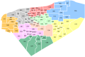 | 751 × 496 (32 KB) | Holmes Mike | {{Information |Description=*{{es icon}} Mapa de los municipios del estado de Yucatán, México (con las regiónes). *{{en icon}} Map of the Municipalities of the State of Yucatán, México (with regions). |Source=*File:Municipios_de_Yucatan.jpg |Da |
File usage
The following pages on the English Wikipedia use this file (pages on other projects are not listed):
- Akil Municipality
- Baca Municipality
- Bokobá Municipality
- Buctzotz Municipality
- Cacalchén Municipality
- Calotmul Municipality
- Cansahcab Municipality
- Cenotillo Municipality
- Chacsinkín Municipality
- Chapab Municipality
- Chemax Municipality
- Chichimilá Municipality
- Chicxulub Pueblo Municipality
- Chikindzonot Municipality
- Chumayel Municipality
- Conkal Municipality
- Cuzamá Municipality
- Dzilam de Bravo Municipality
- Dzitás Municipality
- Dzoncauich Municipality
- Halachó Municipality
- Hoctún Municipality
- Homún Municipality
- Hunucmá Municipality
- Ixil Municipality
- Izamal Municipality
- Kanasín Municipality
- Kantunil Municipality
- Mama Municipality, Yucatán
- Maní Municipality
- Maxcanú Municipality
- Mayapán Municipality
- Muna Municipality
- Progreso Municipality, Yucatán
- Quintana Roo Municipality
- Río Lagartos Municipality
- Sacalum Municipality
- Santa Elena Municipality
- Sucilá Municipality
- Sudzal Municipality
- Tahdziú Municipality
- Tahmek Municipality
- Teabo Municipality
- Tecoh Municipality
- Tekal de Venegas Municipality
- Tekit Municipality
- Tepakán Municipality
- Teya Municipality
- Ticul Municipality
- Timucuy Municipality
- Tixkokob Municipality
- Tixpéhual Municipality
- Tizimín Municipality
- Tunkás Municipality
- Uayma Municipality
- Ucú Municipality
- Umán Municipality
- Xocchel Municipality
- Yobaín Municipality
- Wikipedia:Graphics Lab/Map workshop/Archive/Dec 2015
Global file usage
The following other wikis use this file:
- Usage on nl.wikipedia.org
- Usage on pl.wikipedia.org
- Usage on ru.wikipedia.org
- Usage on sco.wikipedia.org
- Usage on simple.wikipedia.org
- Usage on sv.wikipedia.org
- Usage on tr.wikipedia.org
- Usage on uk.wikipedia.org