
File:Moat near Cudworth - geograph.org.uk - 1548795.jpg

No higher resolution available.
Moat_near_Cudworth_-_geograph.org.uk_-_1548795.jpg (640 × 484 pixels, file size: 104 KB, MIME type: image/jpeg)
| This is a file from the Wikimedia Commons. Information from its description page there is shown below. Commons is a freely licensed media file repository. You can help. |
Summary
| Description |
English: Moat near Cudworth This moat just to the south of the church at Cudworth is probably the remains of a fortified manor house although there is very little in the way of remains inside the moat. The moat is approximately circular and is approximately 75m to 80m in diameter. The interior is slightly higher than the surrounding field. This is the west side of the moat looking north west from just outside the moat on the southern side. There are the remains of fishponds in the adjacent field. Further details can be found here http://homepage.mac.com/philipdavis/English%20sites/3867.html |
| Date | |
| Source | From geograph.org.uk |
| Author | Nigel Mykura |
| Attribution (required by the license) | Nigel Mykura / Moat near Cudworth / |
| Camera location | | View this and other nearby images on: OpenStreetMap |
|---|
| Object location | | View this and other nearby images on: OpenStreetMap |
|---|
Licensing

|
This image was taken from the Geograph project collection. See this photograph's page on the Geograph website for the photographer's contact details. The copyright on this image is owned by Nigel Mykura and is licensed for reuse under the Creative Commons Attribution-ShareAlike 2.0 license.
|
This file is licensed under the Creative Commons Attribution-Share Alike 2.0 Generic license.
Attribution: Nigel Mykura
- You are free:
- to share – to copy, distribute and transmit the work
- to remix – to adapt the work
- Under the following conditions:
- attribution – You must give appropriate credit, provide a link to the license, and indicate if changes were made. You may do so in any reasonable manner, but not in any way that suggests the licensor endorses you or your use.
- share alike – If you remix, transform, or build upon the material, you must distribute your contributions under the same or compatible license as the original.
File history
Click on a date/time to view the file as it appeared at that time.
| Date/Time | Thumbnail | Dimensions | User | Comment | |
|---|---|---|---|---|---|
| current | 10:18, 3 March 2011 | 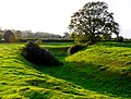 | 640 × 484 (104 KB) | GeographBot | == {{int:filedesc}} == {{Information |description={{en|1=Moat near Cudworth This moat just to the south of the church at Cudworth is probably the remains of a fortified manor house although there is very little in the way of remains inside the moat. The |
File usage
The following pages on the English Wikipedia use this file (pages on other projects are not listed):