
File:Mili.png

Size of this preview: 726 × 599 pixels. Other resolutions: 291 × 240 pixels | 581 × 480 pixels | 872 × 720 pixels.
Original file (872 × 720 pixels, file size: 552 KB, MIME type: image/png)
| This is a file from the Wikimedia Commons. Information from its description page there is shown below. Commons is a freely licensed media file repository. You can help. |
Summary
| Description |
Français : Image satellite de l'atoll de Mili aux Îles Marshall. L'atoll de Nadikdik, visible en bas à droite, était auparavant relié à Mili au niveau du passage Klee.
English: Satellite image of Mili atoll in the Marshall Islands. The Knox Atoll, visible at the bottom right, was previously connected to Mili at Klee Passage. |
| Date | Unknown date |
| Source | http://explorer.worldwind.earth/?layers=Blue%20Marble%20%26%20Landsat&lat=6.0485682&lon=171.9251296&alt=98753.27&heading=0&tilt=0&roll=0 |
| Author | NASA |
Licensing
| This image is in the public domain because it is a screenshot from NASA’s globe software World Wind using a public domain layer, such as Blue Marble, MODIS, Landsat, SRTM, USGS or GLOBE.
|
 |
File history
Click on a date/time to view the file as it appeared at that time.
| Date/Time | Thumbnail | Dimensions | User | Comment | |
|---|---|---|---|---|---|
| current | 00:48, 6 May 2018 | 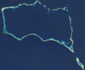 | 872 × 720 (552 KB) | Bastenbas | User created page with UploadWizard |
File usage
The following pages on the English Wikipedia use this file (pages on other projects are not listed):
Global file usage
The following other wikis use this file:
- Usage on es.wikipedia.org
- Usage on eu.wikipedia.org
- Usage on fi.wikipedia.org
- Usage on fr.wikipedia.org
- Usage on gl.wikipedia.org
- Usage on it.wikipedia.org
- Usage on ko.wikipedia.org
- Usage on lv.wikipedia.org
- Usage on mk.wikipedia.org
- Usage on ru.wikipedia.org
- Usage on te.wikipedia.org
- Usage on uk.wikipedia.org
- Usage on zh.wikipedia.org