
File:Milešovka (837 m), satelity s výhledem do krajiny.JPG

Size of this preview: 800 × 533 pixels. Other resolutions: 320 × 213 pixels | 640 × 427 pixels | 1,024 × 683 pixels | 1,280 × 853 pixels | 2,560 × 1,707 pixels | 3,888 × 2,592 pixels.
Original file (3,888 × 2,592 pixels, file size: 3.6 MB, MIME type: image/jpeg)
| This is a file from the Wikimedia Commons. Information from its description page there is shown below. Commons is a freely licensed media file repository. You can help. |
Summary
| Description |
Čeština: Satelity s výhledem do krajiny na Milešovce (837 m). České středohoří, Česká republika.
English: Microwave relay dish and a view of the landscape on Milešovka hill (837 m), České středohoří, Czech Republic. Microwave relay links like this relay telephone calls and television signals between nearby cities. This type of parabolic antenna is called a "shrouded dish". The cylindrical metal shroud attached to the rim of the dish shields it from interference from microwaves coming from other directions, allowing nearby dishes to use the same microwave frequencies. |
||||
| Date | |||||
| Source | Own work | ||||
| Author | Juan de Vojníkov |
| Camera location | | View this and other nearby images on: OpenStreetMap |
|---|
Licensing
I, the copyright holder of this work, hereby publish it under the following license:
This file is licensed under the Creative Commons Attribution-Share Alike 3.0 Unported license.
- You are free:
- to share – to copy, distribute and transmit the work
- to remix – to adapt the work
- Under the following conditions:
- attribution – You must give appropriate credit, provide a link to the license, and indicate if changes were made. You may do so in any reasonable manner, but not in any way that suggests the licensor endorses you or your use.
- share alike – If you remix, transform, or build upon the material, you must distribute your contributions under the same or compatible license as the original.
File history
Click on a date/time to view the file as it appeared at that time.
| Date/Time | Thumbnail | Dimensions | User | Comment | |
|---|---|---|---|---|---|
| current | 09:10, 29 September 2010 | 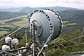 | 3,888 × 2,592 (3.6 MB) | Juandev |
File usage
The following pages on the English Wikipedia use this file (pages on other projects are not listed):
Global file usage
The following other wikis use this file: