
File:Mihrab (marking the direction of the Kaaba in Mecca) - Madrasa of Sultan al-Zahir Barquq (14803204015).jpg

Original file (4,288 × 2,848 pixels, file size: 1.66 MB, MIME type: image/jpeg)
| This is a file from the Wikimedia Commons. Information from its description page there is shown below. Commons is a freely licensed media file repository. You can help. |
Summary
| Description |
English: The Qalawun complex is a massive complex in Cairo, Egypt that includes a madrasa, a hospital and a mausoleum. It was built by the Sultan Al-Nasir Muhammad Ibn Qalawun in the 1280s; some thirty surviving mosques were built during his time.
The Qalawun Complex was built over the ruins of the Fatimid Palace of Cairo, with several halls in the Palace. It was sold to several people until it was finally bought by the Sultan Qalawun in 1283 AD. The structure resides in the heart of Cairo, in the Bayn al-Qasrayn, and has been a center for important religious ceremonies and rituals of the Islamic faith for years, stretching from the Mamluk dynasty through the Ottoman Empire. Within the madrasa the four legal schools, or the four madhhabs of Islamic law were regularly taught. Other teachings housed in the madrasa included the Hadith and the teaching of medicine. The madrasa had two iwans and two recesses as evidenced by the accompanying waqf document. The large courtyard of the madrasa was paved with polychrome marble. The sanctuary of the madrasa "faces the courtyard with a tripartite two-storeyed façade consisting of a central arch flanked by two smaller ones, and surmounted by similar arched openings. These were originally surmounted by three oculi, one above two, and not only one, as is the case today." The mihrab of the madrasa has a horse-shoe arch similar to the mausoleum but is smaller and less elaborate than that of the mausoleum and its conch is marked with glass mosaics and mother-of-pearl, rather than marble mosaics. The deep red color used in the mosaics stands out [Wikipedia.org] |
| Date | |
| Source | Mihrab (marking the direction of the Kaaba in Mecca) - Madrasa of Sultan al-Zahir Barquq - Qalawun complex |
| Author | Jorge Láscar from Melbourne, Australia |
| Camera location | | View this and other nearby images on: OpenStreetMap |
|---|
Licensing
- You are free:
- to share – to copy, distribute and transmit the work
- to remix – to adapt the work
- Under the following conditions:
- attribution – You must give appropriate credit, provide a link to the license, and indicate if changes were made. You may do so in any reasonable manner, but not in any way that suggests the licensor endorses you or your use.
| This image was originally posted to Flickr by Jorge Lascar at https://flickr.com/photos/8721758@N06/14803204015 (archive). It was reviewed on 8 February 2018 by FlickreviewR 2 and was confirmed to be licensed under the terms of the cc-by-2.0. |
File history
Click on a date/time to view the file as it appeared at that time.
| Date/Time | Thumbnail | Dimensions | User | Comment | |
|---|---|---|---|---|---|
| current | 15:54, 8 February 2018 | 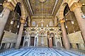 | 4,288 × 2,848 (1.66 MB) | Thesupermat2 | Transferred from Flickr via Flickr2Commons |
File usage
Global file usage
The following other wikis use this file:
- Usage on ar.wikipedia.org
- Usage on fa.wikipedia.org
- Usage on mk.wikipedia.org
- Usage on pl.wikipedia.org
- Usage on pt.wikipedia.org