
File:Merrimack Valley gas explosions house (48787740283).jpg
Size of this preview: 800 × 534 pixels. Other resolutions: 320 × 213 pixels | 640 × 427 pixels | 1,042 × 695 pixels.
Original file (1,042 × 695 pixels, file size: 751 KB, MIME type: image/jpeg)
| This is a file from the Wikimedia Commons. Information from its description page there is shown below. Commons is a freely licensed media file repository. You can help. |
Summary
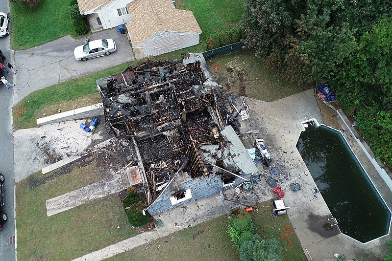
| Description | WASHINGTON (Sept. 24, 2019) — Aerial view of a burned-out home impacted by the Sept. 13, 2018 natural gas explosion and fire in Merrimack Valley, Massachusetts. The photo taken on Sept. 13, 2018 was captured by a drone operated by an NTSB investigator to document the damaged caused by the explosions and fires. (NTSB photo) |
| Date | |
| Source | PLD18MR003-fig03 |
| Author | National Transportation Safety Board |
Licensing
This image is a work of a National Transportation Safety Board employee, taken or made as part of an employee's official duties. As a work of the U.S. federal government, all NTSB images are in the public domain in the United States.
|
| This image was originally posted to Flickr by NTSBgov at https://flickr.com/photos/68618467@N03/48787740283 (archive). It was reviewed on 26 September 2019 by FlickreviewR 2 and was confirmed to be licensed under the terms of the Public Domain Mark. |
File history
Click on a date/time to view the file as it appeared at that time.
| Date/Time | Thumbnail | Dimensions | User | Comment | |
|---|---|---|---|---|---|
| current | 00:08, 26 September 2019 |  | 1,042 × 695 (751 KB) | MarginalCost | Transferred from Flickr via #flickr2commons |
File usage
The following pages on the English Wikipedia use this file (pages on other projects are not listed):
Global file usage
The following other wikis use this file:
- Usage on www.wikidata.org