
File:Mayrland Glassmaking Centers 1780-1800.png

Size of this preview: 800 × 530 pixels. Other resolutions: 320 × 212 pixels | 640 × 424 pixels | 1,068 × 707 pixels.
Original file (1,068 × 707 pixels, file size: 1.39 MB, MIME type: image/png)
| This is a file from the Wikimedia Commons. Information from its description page there is shown below. Commons is a freely licensed media file repository. You can help. |
Summary
| Description |
English: This 1795 map of Maryland has been modified by TwoScarsUp to show (red circles) glassmaking areas in Maryland from 1760 to 1800. |
| Date | |
| Source |
Library of Congress, Geography and Map Division https://www.loc.gov/item/gm71000977/ |
| Author |
Lewis, Samuel, 1753 or 1754-1822. Barker, W. (William), active 1795-1803. Carey, Mathew, 1760-1839. Guthrie, William, 1708-1770 |
Licensing
| This file is made available under the Creative Commons CC0 1.0 Universal Public Domain Dedication. | |
| The person who associated a work with this deed has dedicated the work to the public domain by waiving all of their rights to the work worldwide under copyright law, including all related and neighboring rights, to the extent allowed by law. You can copy, modify, distribute and perform the work, even for commercial purposes, all without asking permission.
|
File history
Click on a date/time to view the file as it appeared at that time.
| Date/Time | Thumbnail | Dimensions | User | Comment | |
|---|---|---|---|---|---|
| current | 18:04, 17 January 2024 | 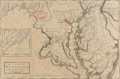 | 1,068 × 707 (1.39 MB) | TwoScarsUp | Uploaded a work by Lewis, Samuel, 1753 or 1754-1822. Barker, W. (William), active 1795-1803. Carey, Mathew, 1760-1839. Guthrie, William, 1708-1770 from Library of Congress, Geography and Map Division https://www.loc.gov/item/gm71000977/ with UploadWizard |
File usage
The following pages on the English Wikipedia use this file (pages on other projects are not listed):