
File:May 15, 2013 tornado outbreak map.png

No higher resolution available.
May_15,_2013_tornado_outbreak_map.png (582 × 408 pixels, file size: 16 KB, MIME type: image/png)
| This is a file from the Wikimedia Commons. Information from its description page there is shown below. Commons is a freely licensed media file repository. You can help. |
Summary
| Description |
English: The National Weather Service map for the May 15, 2013 tornado outbreak. Most damage and tornadoes occurred in the Dallas-Fort Worth region of Texas. |
| Date | |
| Source | http://www.spc.noaa.gov/climo/reports/130515_rpts.html |
| Author | NOAA/National Weather Service (NWS) |
Licensing
This image is in the public domain because it contains materials that originally came from the U.S. National Oceanic and Atmospheric Administration, taken or made as part of an employee's official duties.
|
File history
Click on a date/time to view the file as it appeared at that time.
| Date/Time | Thumbnail | Dimensions | User | Comment | |
|---|---|---|---|---|---|
| current | 18:09, 18 May 2013 | 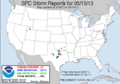 | 582 × 408 (16 KB) | Eyesnore | Newly updated preliminary storm reports from NOAA (update 1208Z at 5/18/2013) |
| 03:05, 17 May 2013 |  | 579 × 406 (35 KB) | A Texas Historian | Oops, uploaded the wrong version. Hope this one is right. | |
| 03:03, 17 May 2013 |  | 579 × 406 (35 KB) | A Texas Historian | Updated version provided by NOAA | |
| 21:27, 16 May 2013 |  | 579 × 406 (45 KB) | A Texas Historian | User created page with UploadWizard |
File usage
The following pages on the English Wikipedia use this file (pages on other projects are not listed):