
File:Mawar 2023-05-26 0405Z.jpg
Size of this preview: 462 × 599 pixels. Other resolutions: 185 × 240 pixels | 370 × 480 pixels | 592 × 768 pixels | 789 × 1,024 pixels | 1,579 × 2,048 pixels | 3,700 × 4,800 pixels.
Original file (3,700 × 4,800 pixels, file size: 12.01 MB, MIME type: image/jpeg)
| This is a file from the Wikimedia Commons. Information from its description page there is shown below. Commons is a freely licensed media file repository. You can help. |
Summary
| Description |
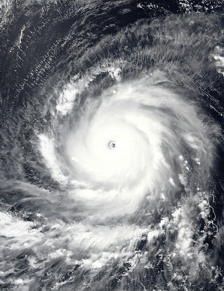
English: This true-color image of Typhoon Mawar (later known as "Betty" in the Philippines) over the Philippine Sea was captured on the afternoon of May 26, 2023, at 04:05 UTC, by the Visible Infrared Imaging Radiometer Suite (VIIRS) instrument flying aboard NOAA's Suomi-NPP satellite. Mawar was an extremely powerful typhoon that affected parts of the Indo-Pacific, particularly Guam, the Mariana Islands, the Philippines, and Taiwan, and the Southern Japanese Islands. The fourth depression, the second named storm (officially), the first typhoon, and the first violent typhoon of the 2023 West Pacific typhoon season. It originated from a tropical disturbance near Micronesia in mid-May 2023, where it began its track in a northwestward direction through the Mariana Islands and toward Guam. On May 24, Mawar passed by Guam, causing at least $4.3 billion (2023) in damage to the Island Territory. Mawar has contributed to six causalities in total two in Guam, one in Taiwan, one in the Philippines, and two in Japan. When this image was taken, Mawar was at its secondary and most intense peak intensity and moving west toward the Philippine Islands. The intensity of the typhoon when this image was taken was winds of 210 km/h (130 mph) (115 knots) on the 10-min Japan Meteorological Agency typhoon scale, making it a "Violent typhoon" on the scale, and according to the Joint Typhoon Warning Center, it had 1-min sustained winds of 295 km/h (185 mph) (160 knots) making it equivalent to an extremely powerful "Category 5 major hurricane," on the Saffir-Simpson Hurricane Wind Scale the fifth to reach that intensity during the year so far. The official minimum central pressure (provided by the JMA) was 900 mbar (26.6 inHg) and its unofficial minimum pressure (provided by the JTWC) was 897 mbar (26.5 inHg), this makes Mawar one of the most intense typhoons to occur in May in the Western Pacific basin, and so far the most intense globally during the current calendar year tied with Typhoon Bolaven in October. |
| Date | |
| Source | EOSDIS Worldview |
| Author | VIIRS imagery from NOAA's Suomi-NPP Satellite |
Licensing
This image is in the public domain because it contains materials that originally came from the U.S. National Oceanic and Atmospheric Administration, taken or made as part of an employee's official duties.
|
File history
Click on a date/time to view the file as it appeared at that time.
| Date/Time | Thumbnail | Dimensions | User | Comment | |
|---|---|---|---|---|---|
| current | 21:16, 26 May 2023 |  | 3,700 × 4,800 (12.01 MB) | TheWxResearcher | Tweaked Brightness |
| 21:00, 26 May 2023 |  | 3,700 × 4,800 (11.1 MB) | TheWxResearcher | Uploaded a work by VIIRS imagery from NOAA's Suomi-NPP Satellite from [https://worldview.earthdata.nasa.gov/ EOSDIS Worldview] with UploadWizard |
File usage
The following pages on the English Wikipedia use this file (pages on other projects are not listed):
Global file usage
The following other wikis use this file:
- Usage on es.wikipedia.org
- Usage on ja.wikipedia.org
- Usage on ko.wikipedia.org
- Usage on pt.wikipedia.org
- Usage on th.wikipedia.org
- Usage on tl.wikipedia.org
- Usage on uk.wikipedia.org
- Usage on www.wikidata.org
- Usage on zh.wikipedia.org