
File:Map of the Chagatai Khanate circa 1300 CE.png

Size of this preview: 800 × 460 pixels. Other resolutions: 320 × 184 pixels | 640 × 368 pixels | 1,024 × 589 pixels | 1,280 × 736 pixels | 3,196 × 1,837 pixels.
Original file (3,196 × 1,837 pixels, file size: 14.8 MB, MIME type: image/png)
| This is a file from the Wikimedia Commons. Information from its description page there is shown below. Commons is a freely licensed media file repository. You can help. |
Summary
| Description |
English: Map of the Chagatai Khanate circa 1300 CE |
| Date | |
| Source | |
| Author | naturalearthdata.com |
| Other versions |
 |
Licensing

|
Permission is granted to copy, distribute and/or modify this document under the terms of the GNU Free Documentation License, Version 1.2 or any later version published by the Free Software Foundation; with no Invariant Sections, no Front-Cover Texts, and no Back-Cover Texts. A copy of the license is included in the section entitled GNU Free Documentation License. |
| This file is licensed under the Creative Commons Attribution-Share Alike 3.0 Unported license. | ||
| ||
| This licensing tag was added to this file as part of the GFDL licensing update. |
File history
Click on a date/time to view the file as it appeared at that time.
| Date/Time | Thumbnail | Dimensions | User | Comment | |
|---|---|---|---|---|---|
| current | 11:39, 16 February 2023 | 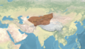 | 3,196 × 1,837 (14.8 MB) | पाटलिपुत्र | territory |
| 11:38, 10 February 2023 |  | 6,393 × 3,674 (56.36 MB) | पाटलिपुत्र | Uploaded a work by Map created from [http://www2.demis.nl/mapserver/mapper.asp DEMIS Mapserver], which are public domain. Koba-chan from {{extracted from|File:Topographic90deg N0E0.png}} {{extracted from|File:Topographic90deg N0E90.png}} with UploadWizard |
File usage
The following pages on the English Wikipedia use this file (pages on other projects are not listed):
Global file usage
The following other wikis use this file:
- Usage on mn.wikipedia.org
- Usage on tr.wikipedia.org