
File:Map of the British Isles from Robert Modern's Geography Rectified, 1680.jpg

Original file (7,848 × 5,308 pixels, file size: 6.29 MB, MIME type: image/jpeg)
| This is a file from the Wikimedia Commons. Information from its description page there is shown below. Commons is a freely licensed media file repository. You can help. |
Summary
| Description |
English: 17th-century printed map of the British Isles from Robert Modern's Geography Rectified, London, 1680, with the map on the verso (page 12) and the first page of the relevant chapter on the recto (page 13). |
||||||||||||||||||||||
| Date | |||||||||||||||||||||||
| Source | https://www.davidrumsey.com/luna/servlet/detail/RUMSEY~8~1~335302~90103188 | ||||||||||||||||||||||
| Author |
|
||||||||||||||||||||||
Licensing
|
This work is in the public domain in its country of origin and other countries and areas where the copyright term is the author's life plus 70 years or fewer.
| |
| This file has been identified as being free of known restrictions under copyright law, including all related and neighboring rights. | |
File history
Click on a date/time to view the file as it appeared at that time.
| Date/Time | Thumbnail | Dimensions | User | Comment | |
|---|---|---|---|---|---|
| current | 19:56, 27 March 2024 | 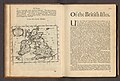 | 7,848 × 5,308 (6.29 MB) | The wisest fool in Christendom | Uploaded a work by {{Creator:Robert Morden}} from https://www.davidrumsey.com/luna/servlet/detail/RUMSEY~8~1~335302~90103188 with UploadWizard |