
File:Map of al-Hawl & Sinjar offensives, 12 Nov 2015.jpg

Size of this preview: 800 × 353 pixels. Other resolutions: 320 × 141 pixels | 640 × 282 pixels | 1,466 × 647 pixels.
Original file (1,466 × 647 pixels, file size: 461 KB, MIME type: image/jpeg)
| This is a file from the Wikimedia Commons. Information from its description page there is shown below. Commons is a freely licensed media file repository. You can help. |
Summary
| Description |
English: The situation along Hasakah – SInjar – Mosul axis, on 12 Nov 2015. |
| Date | |
| Source | NE-Syria-NW-IRAQ-12112015.jpg in THE SITUATION ALONG HASAKAH – SINJAR – MOSUL AXIS (12 NOV 2015) |
| Author | Agathocle deSyracuse |
| Permission (Reusing this file) |
Permission was provided at http://www.agathocledesyracuse.com/archives/52, where the author stated that the maps on his site could be partially or fully reused if credited (Ex: @deSyracuse). |
Licensing

|
The copyright holder of this file allows anyone to use it for any purpose, provided that the copyright holder is properly attributed. Redistribution, derivative work, commercial use, and all other use is permitted. |
|
|
File history
Click on a date/time to view the file as it appeared at that time.
| Date/Time | Thumbnail | Dimensions | User | Comment | |
|---|---|---|---|---|---|
| current | 13:36, 14 November 2015 | 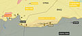 | 1,466 × 647 (461 KB) | PanchoS | File:The situation along Hasakah – SInjar – Mosul axis (12 Nov 2015).jpg cropped 27 % horizontally and 24 % vertically using CropTool with lossless mode. |
.jpg)
File usage
The following pages on the English Wikipedia use this file (pages on other projects are not listed):
Global file usage
The following other wikis use this file:
- Usage on ar.wikipedia.org
- Usage on de.wikipedia.org
- Usage on es.wikipedia.org
- Usage on fr.wikipedia.org
- Usage on hu.wikipedia.org
- Usage on id.wikipedia.org
- Usage on ru.wikipedia.org
- Usage on www.wikidata.org
- Usage on zh.wikipedia.org