
File:Map of Warren County, Indiana.svg
Size of this PNG preview of this SVG file: 600 × 600 pixels. Other resolutions: 240 × 240 pixels | 480 × 480 pixels | 768 × 768 pixels | 1,024 × 1,024 pixels | 2,048 × 2,048 pixels.
Original file (SVG file, nominally 768 × 768 pixels, file size: 583 KB)
| This is a file from the Wikimedia Commons. Information from its description page there is shown below. Commons is a freely licensed media file repository. You can help. |
Summary
| Description |
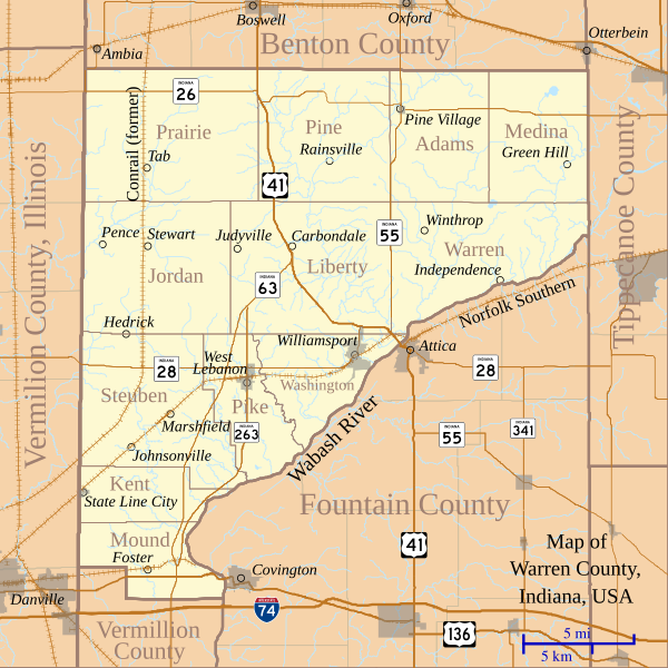
English: This is a map of Warren County, Indiana, USA which shows settlements, county and township borders, and major transportation routes. |
| Date | |
| Source | My own work, using custom-written MapScript applications with freely-available United States Census Bureau TIGER data |
| Author | Omnedon |
Licensing
| I, the copyright holder of this work, release this work into the public domain. This applies worldwide. In some countries this may not be legally possible; if so: I grant anyone the right to use this work for any purpose, without any conditions, unless such conditions are required by law. |
File history
Click on a date/time to view the file as it appeared at that time.
| Date/Time | Thumbnail | Dimensions | User | Comment | |
|---|---|---|---|---|---|
| current | 04:15, 8 September 2011 |  | 768 × 768 (583 KB) | Omnedon | == {{int:filedesc}} == {{Information |Description={{en|This is a map of Warren County, Indiana, USA which shows settlements, county and township borders, and major transportation routes.}} |Source=My own work, using custom-wr |
| 15:26, 13 February 2011 |  | 768 × 768 (731 KB) | Omnedon | == {{int:filedesc}} == {{Information |Description={{en|This is a map of Warren County, Indiana, USA which includes incorporated settlements, township borders and major transportation routes.}} |Source=My own work, using custo | |
| 15:45, 22 August 2010 |  | 768 × 768 (193 KB) | Omnedon | == {{int:filedesc}} == {{Information |Description={{en|This is a map of Warren County, Indiana, USA which shows settlements, townships, roads, railroads, and major rivers.}} |Source=My own work, using freely-available shape data and custom-written MapScri | |
| 04:45, 18 February 2008 |  | 768 × 768 (70 KB) | Omnedon | {{Information |Description={{en|This is a map of Warren County, Indiana, USA which shows settlements, townships, roads, railroads, and major rivers.}} |Source=My own work, using freely-available shape data and custom-written MapScript applications |Date=2 | |
| 22:17, 15 February 2008 |  | 768 × 768 (68 KB) | Omnedon | {{Information |Description={{en|This is a map of Warren County, Indiana, USA which shows settlements, townships, roads, railroads, and major rivers.}} |Source=My own work, using freely-available shape data and custom-written MapScript applications |Date=2 |
File usage
The following pages on the English Wikipedia use this file (pages on other projects are not listed):
Global file usage
The following other wikis use this file:
- Usage on de.wikipedia.org
- Usage on es.wikipedia.org
- Usage on fr.wikipedia.org
- Usage on ja.wikipedia.org