
File:Map of Russian districts, 2010-01-19.svg
Size of this PNG preview of this SVG file: 800 × 462 pixels. Other resolutions: 320 × 185 pixels | 640 × 369 pixels | 1,024 × 591 pixels | 1,280 × 738 pixels | 2,560 × 1,477 pixels | 1,092 × 630 pixels.
Original file (SVG file, nominally 1,092 × 630 pixels, file size: 196 KB)
| This is a file from the Wikimedia Commons. Information from its description page there is shown below. Commons is a freely licensed media file repository. You can help. |
| Description |
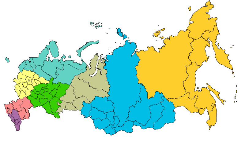
Map of the Federal districts of Russia with merged subjects (01.03.2008, last merger Chita Oblast+Agin-Buryat Autonomous Okrug to form Zabaykalsky Krai.) Central Federal District Southern Federal District Northwestern Federal District Far Eastern Federal District Siberian Federal District Urals Federal District Volga Federal District
North Caucasian Federal District |
| Date | (UTC) |
| Source | |
| Author |
|
| This is a retouched picture, which means that it has been digitally altered from its original version. The original can be viewed here: Map of Russian districts, 2008-03-01.svg:
|
I, the copyright holder of this work, hereby publish it under the following license:
This file is licensed under the Creative Commons Attribution-Share Alike 2.5 Generic license.
- You are free:
- to share – to copy, distribute and transmit the work
- to remix – to adapt the work
- Under the following conditions:
- attribution – You must give appropriate credit, provide a link to the license, and indicate if changes were made. You may do so in any reasonable manner, but not in any way that suggests the licensor endorses you or your use.
- share alike – If you remix, transform, or build upon the material, you must distribute your contributions under the same or compatible license as the original.
Original upload log
This image is a derivative work of the following images:
- File:Map_of_Russian_districts,_2008-03-01.svg licensed with Cc-by-sa-2.5
- 2008-03-03T23:20:48Z Lokal Profil 1092x630 (260469 Bytes) Removed surrounding countries
- 2008-03-03T23:15:39Z Lokal Profil 1092x630 (296735 Bytes) {{Information |Description=Map of the [[:en:Federal districts of Russia|Federal districts of Russia]] with merged subjects (01.03.2008, last merger [[w:en:Chita Oblast|Chita Oblast]]+[[w:en:Agin-Buryat Autonomous Okrug|Agin-B
Uploaded with derivativeFX
File history
Click on a date/time to view the file as it appeared at that time.
| Date/Time | Thumbnail | Dimensions | User | Comment | |
|---|---|---|---|---|---|
| current | 14:44, 23 March 2014 |  | 1,092 × 630 (196 KB) | Denniss | Reverted to version as of 23:59, 22 March 2014 |
| 13:29, 23 March 2014 |  | 1,092 × 630 (220 KB) | Preguntador | Reverted to version as of 11:28, 22 March 2014 | |
| 23:59, 22 March 2014 |  | 1,092 × 630 (196 KB) | Tibet2014 | The file is named 2010-01-19, please upload new version as new file | |
| 11:28, 22 March 2014 |  | 1,092 × 630 (220 KB) | Anton-rigin | Reverted to version as of 22:00, 21 March 2014/We can dispute about legality of referendum, but Russian federal districts are Russian domestic policy. | |
| 01:59, 22 March 2014 |  | 1,092 × 630 (196 KB) | Bobek | Reverted to version as of 16:25, 19 January 2010 | |
| 22:00, 21 March 2014 |  | 1,092 × 630 (220 KB) | Knyaz-1988 | New version | |
| 16:25, 19 January 2010 |  | 1,092 × 630 (196 KB) | SeNeKa~commonswiki | {{Information |Description=Map of the Federal districts of Russia with merged subjects (01.03.2008, last merger Chita Oblast+Agin-Buryat Autonomous Okrug to fo |
File usage
The following pages on the English Wikipedia use this file (pages on other projects are not listed):
Global file usage
The following other wikis use this file:
- Usage on av.wikipedia.org
- Usage on bg.wikipedia.org
- Usage on bxr.wikipedia.org
- Usage on cy.wikipedia.org
- Usage on de.wikipedia.org
- Usage on de.wikivoyage.org
- Usage on eo.wikipedia.org
- Usage on fa.wikipedia.org
- Usage on fi.wikipedia.org
- Usage on fr.wikipedia.org
- Usage on hr.wikipedia.org
- Usage on hu.wikipedia.org
- Usage on id.wikipedia.org
- Usage on koi.wikipedia.org
- Шаблон:Федерал кытшшез Рочмуын
- Волгадор федерал кытш
- Категория:Ойвыв-Рытвыв федерал кытш
- Категория:Сибир федерал кытш
- Категория:Волгадор федерал кытш
- Категория:Урал федерал кытш
- Категория:Лунвыв федерал кытш
- Категория:Медшӧр федерал кытш
- Ылісь Асыввыв федерал кытш
- Категория:Ылісь Асыввыв федерал кытш
- Категория:Федерал кытшшез Рочмуын
- Категория:Ылiсь Асыввыв федерал кытш
- Категория:Медшöр федерал кытш
- Usage on mk.wikipedia.org
- Usage on mr.wikipedia.org
- Usage on pfl.wikipedia.org
- Usage on pt.wikipedia.org
View more global usage of this file.