
File:Map of Palms neighborhood, Los Angeles, California.png
No higher resolution available.
Map_of_Palms_neighborhood,_Los_Angeles,_California.png (696 × 452 pixels, file size: 490 KB, MIME type: image/png)
| This is a file from the Wikimedia Commons. Information from its description page there is shown below. Commons is a freely licensed media file repository. You can help. |
Summary
| Description |
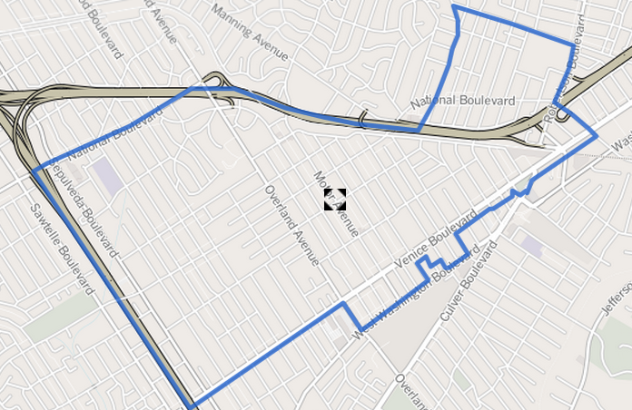
English: Map of the boundaries of the Palms neighborhood in Westside Los Angeles, California.
|
| Date | Unknown date |
| Source | http://projects.latimes.com/mapping-la/neighborhoods/neighborhood/palms/?q=Palms%2C+Los+Angeles%2C+CA%2C+USA&lat=34.0244133&lng=-118.4075474&g=Geocodify |
| Author | Los Angeles Times |
| Permission (Reusing this file) |
https://creativecommons.org/licenses/by-sa/2.0/ |
- Other information
English: Info at bottom right of map on original web page states "C Open Street Map contributors CC-BY-SA," which link leads to this page: https://creativecommons.org/licenses/by-sa/2.0/
Licensing
This file is licensed under the Creative Commons Attribution-Share Alike 3.0 Unported license.
- You are free:
- to share – to copy, distribute and transmit the work
- to remix – to adapt the work
- Under the following conditions:
- attribution – You must give appropriate credit, provide a link to the license, and indicate if changes were made. You may do so in any reasonable manner, but not in any way that suggests the licensor endorses you or your use.
- share alike – If you remix, transform, or build upon the material, you must distribute your contributions under the same or compatible license as the original.
File history
Click on a date/time to view the file as it appeared at that time.
| Date/Time | Thumbnail | Dimensions | User | Comment | |
|---|---|---|---|---|---|
| current | 15:48, 22 April 2013 |  | 696 × 452 (490 KB) | BeenAroundAWhile | {{subst:Upload marker added by en.wp UW}} {{Information |Description = {{en|Map of the boundaries of the Palms neighborhood in Los Angeles, California, as determined by the "Mapping L.A." project of the Los Angeles Times. Will be used at [[:en:Palms, L... |
File usage
The following pages on the English Wikipedia use this file (pages on other projects are not listed):
Global file usage
The following other wikis use this file:
- Usage on www.wikidata.org