
File:Map of Mystras-en.svg
Size of this PNG preview of this SVG file: 732 × 571 pixels. Other resolutions: 308 × 240 pixels | 615 × 480 pixels | 985 × 768 pixels | 1,280 × 998 pixels | 2,560 × 1,997 pixels.
Original file (SVG file, nominally 732 × 571 pixels, file size: 264 KB)
| This is a file from the Wikimedia Commons. Information from its description page there is shown below. Commons is a freely licensed media file repository. You can help. |
Summary
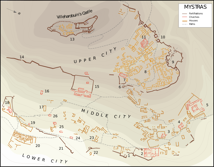
| Description | Plan of Mystras after G. Millet (1910) and M. Chatzidakis (1981) works. Key : 1. Main entrance ; 2. Metropolis ; 3. Evangelistria ; 4. Saint-Theodores ; 5. Hodigitria-Afendiko ; 6. Monemvasia's Gate ; 7. Saint-Nicolas ; 8. The Despots Palace and the square ; 9. Nauplia's Gate ; 10. Upper entrance to the citadel ; 11. Saint-Sophia ; 12. Small Palace ; 13. Citadel ; 14. Mavroporta ; 15. Pantanassa ; 16. Taxiarchs ; 17. Frangopoulos' House ; 18. Peribleptos ; 19. Saint-Georges ; 20. Krevata House ; 21. Marmara (entrance) ; 22. Aï-Yannakids ; 23. Laskaris' House ; 24. Saint-Christopher ; 25. Ruins ; 26. Saint-Kyriaki. |
| Date | |
| Source | Own work |
| Author | Marsyas |
| Other versions |
[]
|


Licensing
I, the copyright holder of this work, hereby publish it under the following license:
This file is licensed under the Creative Commons Attribution 3.0 Unported license.
- You are free:
- to share – to copy, distribute and transmit the work
- to remix – to adapt the work
- Under the following conditions:
- attribution – You must give appropriate credit, provide a link to the license, and indicate if changes were made. You may do so in any reasonable manner, but not in any way that suggests the licensor endorses you or your use.
File history
Click on a date/time to view the file as it appeared at that time.
| Date/Time | Thumbnail | Dimensions | User | Comment | |
|---|---|---|---|---|---|
| current | 14:37, 6 September 2013 |  | 732 × 571 (264 KB) | Cplakidas | rmv whitespace, text to paths |
| 07:07, 26 March 2008 |  | 850 × 651 (1.49 MB) | Marsyas | {{Information |Description= |Source=self-made |Date= |Author= Marsyas |Permission= |other_versions= }} | |
| 07:03, 26 March 2008 |  | 850 × 651 (2 MB) | Marsyas | == Summary == {{Information |Description=Plan de Mistra d'après le relevé de G. Millet (1910) revu par M. Chatzidakis (1981). Légende : 1. Entrée principale ; 2. Métropole ; 3. Évangélistria ; 4. Saints-Théodores ; 5. Hodigitria-Afendiko ; 6. Port |
File usage
The following pages on the English Wikipedia use this file (pages on other projects are not listed):
Global file usage
The following other wikis use this file:
- Usage on de.wikipedia.org
- Usage on de.wikivoyage.org
- Usage on eo.wikipedia.org
- Usage on fi.wikipedia.org
- Usage on hr.wikipedia.org
- Usage on mt.wikipedia.org
- Usage on sh.wikipedia.org
- Usage on sl.wikipedia.org
- Usage on tr.wikipedia.org
- Usage on zh.wikipedia.org