
File:Map of Alabama terrain NA.jpg

Size of this preview: 362 × 599 pixels. Other resolutions: 145 × 240 pixels | 290 × 480 pixels | 810 × 1,340 pixels.
Original file (810 × 1,340 pixels, file size: 244 KB, MIME type: image/jpeg)
| This is a file from the Wikimedia Commons. Information from its description page there is shown below. Commons is a freely licensed media file repository. You can help. |
Summary
| Description | Scalable map of the U.S. state of Alabama, showing terrain features: hills, lakes, rivers, roads and major towns, in quick photographic format (JPEG) to highlight terrain features. Natural Bridge, Mount Cheaha, and nearby states are labeled; the Interstate icons are enlarged 10%; and major cities are bolded 20% for readability when scaled to 310px display width. The distance scale is shown in miles/kilometers, and labels appear 4x times larger than original in the US National Atlas, at similar display width. |
| Date | |
| Source | National Atlas (cropped to extract terrain only, no legend, with several names enlarged/added) |
| Author | User:Wikid77 (from National Atlas of the United States) |
| Other versions |
The map has some related variations:
|
Licensing
This map was obtained from an edition of the National Atlas of the United States. Like almost all works of the U.S. federal government, works from the National Atlas are in the public domain in the United States.
Online access: NationalAtlas.gov | 1970 print edition: Library of Congress, Perry-Castañeda Library
|
File history
Click on a date/time to view the file as it appeared at that time.
| Date/Time | Thumbnail | Dimensions | User | Comment | |
|---|---|---|---|---|---|
| current | 12:39, 1 October 2007 | 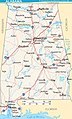 | 810 × 1,340 (244 KB) | Wikid77 | enlarged "Cheaha" & "Natural Bridge"; enlarged 15 names; added "Fairhope" |
| 18:12, 11 August 2007 |  | 810 × 1,340 (243 KB) | Wikid77 | reduced map height 5% to magnify description-page image 5% (article map same width); clarified some "-ville" suffixes | |
| 12:11, 11 August 2007 |  | 810 × 1,410 (252 KB) | Wikid77 | narrowed map to magnify 4% (people notice 2%+), enlarged scale (miles+20% km+10%) "Selma" 40%; clarified many names; split "West/Point" lake | |
| 05:33, 10 August 2007 | 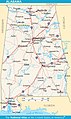 | 840 × 1,410 (252 KB) | Wikid77 | enlarged "Selma" 30% and Interstate icons by 10%; clarified other town names | |
| 04:03, 10 August 2007 |  | 840 × 1,410 (251 KB) | Wikid77 | added "Natural Bridge" and enlarged "Selma"/"Cheaha" 20%; in "Birmingham" split "r/m"; aligned "Haleyville" / "Opelika"; clarified "Birmingham" roads | |
| 05:57, 25 July 2007 |  | 840 × 1,410 (250 KB) | Wikid77 | labeled "TENNESSEE" & clarify/copy I-10 icon @Florida; darken Birmingham, Huntsville, Tuscaloosa, Dothan, Mobile. | |
| 12:09, 24 July 2007 |  | 840 × 1,410 (249 KB) | Wikid77 | {{Information| | Description=Map of the U.S. state of Alabama, showing terrain features: hills, lakes, rivers, roads and major towns, in quick photographic format (JPEG) to highlight terrain features. | Source=[http://www.nationalatlas.gov Nationa |
File usage
The following pages on the English Wikipedia use this file (pages on other projects are not listed):
Global file usage
The following other wikis use this file:
- Usage on az.wikipedia.org
- Usage on bo.wikipedia.org
- Usage on da.wikipedia.org
- Usage on de.wikivoyage.org
- Usage on el.wikipedia.org
- Usage on fa.wikipedia.org
- Usage on fi.wikipedia.org
- Usage on gag.wikipedia.org
- Usage on he.wikivoyage.org
- Usage on id.wikipedia.org
- Usage on io.wikipedia.org
- Usage on ja.wikipedia.org
- Usage on kk.wikipedia.org
- Usage on lt.wikipedia.org
- Usage on mk.wikipedia.org
- Usage on ml.wikipedia.org
- Usage on nl.wikipedia.org
- Usage on nl.wiktionary.org
- Usage on no.wikipedia.org
- Usage on pam.wikipedia.org
- Usage on pl.wikipedia.org
- Usage on pt.wikipedia.org
- Usage on ru.wikipedia.org
- Usage on sd.wikipedia.org
- Usage on simple.wikipedia.org
- Usage on sw.wikipedia.org
- Usage on szl.wikipedia.org
- Usage on tr.wikipedia.org
- Usage on uk.wikipedia.org
- Usage on vi.wikipedia.org
- Usage on zh.wikipedia.org