
File:Map for the Silesian and Seven Years Wars.jpg
Size of this preview: 800 × 592 pixels. Other resolutions: 320 × 237 pixels | 640 × 474 pixels | 1,024 × 758 pixels | 1,280 × 948 pixels | 1,672 × 1,238 pixels.
Original file (1,672 × 1,238 pixels, file size: 438 KB, MIME type: image/jpeg)
| This is a file from the Wikimedia Commons. Information from its description page there is shown below. Commons is a freely licensed media file repository. You can help. |
Summary
| Description |
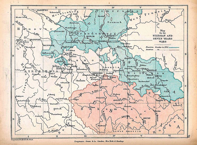
English: A map of Central Europe depicting the principal regions of conflict in the Silesian Wars of the 1740s–60s. The blue and red regions highlight Prussian and Austrian territory (respectively) as of 1756. |
| Date | |
| Source | The map is taken from "The Public Schools Historical Atlas" by Charles Colbeck. Longmans, Green, & Co.: New York; London; Bombay. 1905. It was accessed through the University of Texas at Austin's Perry-Castañeda Library Map Collection. The original map comes from "Frederick the Great and the Seven Years' War" by Frederick William Longman (1881). |
| Author |
Frederick William Longman Charles Colbeck (editor) |
Licensing
|
The author died in 1908, so this work is in the public domain in its country of origin and other countries and areas where the copyright term is the author's life plus 100 years or fewer. This work is in the public domain in the United States because it was published (or registered with the U.S. Copyright Office) before January 1, 1929. | |
| This file has been identified as being free of known restrictions under copyright law, including all related and neighboring rights. | |
File history
Click on a date/time to view the file as it appeared at that time.
| Date/Time | Thumbnail | Dimensions | User | Comment | |
|---|---|---|---|---|---|
| current | 12:25, 7 October 2019 |  | 1,672 × 1,238 (438 KB) | Soerfm | Contrast |
| 17:42, 7 January 2019 |  | 1,672 × 1,238 (338 KB) | Bryanrutherford0 | User created page with UploadWizard |
File usage
The following pages on the English Wikipedia use this file (pages on other projects are not listed):
- First Silesian War
- Second Silesian War
- Silesian Wars
- Third Silesian War
- Wikipedia:Featured and good topic candidates/Featured log/June 2019
- Wikipedia:Featured and good topic candidates/Good log/June 2019
- Wikipedia:Featured and good topic candidates/Silesian Wars/archive1
- Wikipedia:Featured topics
- Wikipedia:Featured topics/Silesian Wars
- Wikipedia:Today's featured article/requests/Silesian Wars
Global file usage
The following other wikis use this file:
- Usage on cs.wikipedia.org
- Usage on es.wikipedia.org
- Usage on fr.wikipedia.org
- Usage on he.wikipedia.org
- Usage on id.wikipedia.org
- Usage on ja.wikipedia.org
- Usage on ka.wikipedia.org
- Usage on pt.wikipedia.org
- Usage on ru.wikipedia.org
- Usage on sr.wikipedia.org
- Usage on vi.wikipedia.org
- Usage on zh.wikipedia.org