
File:Map Remains of Franklin's Lost Expedition.svg

Size of this PNG preview of this SVG file: 340 × 598 pixels. Other resolutions: 136 × 240 pixels | 272 × 480 pixels | 436 × 768 pixels | 582 × 1,024 pixels | 1,163 × 2,048 pixels | 709 × 1,248 pixels.
Original file (SVG file, nominally 709 × 1,248 pixels, file size: 2.73 MB)
| This is a file from the Wikimedia Commons. Information from its description page there is shown below. Commons is a freely licensed media file repository. You can help. |
Summary
| Description |
English: Map of the west coast of King William Island depicting confirmed remains of Franklin's Lost Expedition
(Note that the location where the ships were abandoned and the site of Victory Point is to a certain extent speculative, see Cyriax 1952.) |
| Date | |
| Source | Own work |
| Author | Smurftrooper |
Sources:
- Ship Remains: Parks Canada: "Wrecks of HMS Erebus and HMS Terror National Historic Site: Superintendent's order", 2019-05-27, https://www.pc.gc.ca/en/lhn-nhs/nu/epaveswrecks/info/plan
- Sites of Human Remains:
- "Confirmed Sites" from: Stenton, Douglas R. (30 October 2018). "Finding the dead: bodies, bones and burials from the 1845 Franklin northwest passage Expedition". Polar Record. 54 (3): 197–212. doi:10.1017/S0032247418000359
- Erebus Bay Locations from: Stenton, Douglas; Keenleyside, A.; Fratpetro, S.; Park, R. (2017). "DNA analysis of human skeletal remains from the 1845 Franklin expedition". Journal of Archaeological Science: Reports. 16: 409–419. doi:10.1016/j.jasrep.2017.03.041
- Victory Point and ship abandonment site: Cyriax, R. J. (1952). The position of Victory Point, King William Island. Polar Record, 6(44), 496-507.
- Base Map: Statistics Canada: Boundary Files (Province and Territory), 2016 Census. Statistics Canada Catalogue no. 92-160-X.
Licensing
I, the copyright holder of this work, hereby publish it under the following license:
This file is licensed under the Creative Commons Attribution-Share Alike 4.0 International license.
- You are free:
- to share – to copy, distribute and transmit the work
- to remix – to adapt the work
- Under the following conditions:
- attribution – You must give appropriate credit, provide a link to the license, and indicate if changes were made. You may do so in any reasonable manner, but not in any way that suggests the licensor endorses you or your use.
- share alike – If you remix, transform, or build upon the material, you must distribute your contributions under the same or compatible license as the original.
File history
Click on a date/time to view the file as it appeared at that time.
| Date/Time | Thumbnail | Dimensions | User | Comment | |
|---|---|---|---|---|---|
| current | 08:42, 22 January 2021 | 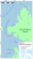 | 709 × 1,248 (2.73 MB) | Smurftrooper | Uploaded own work with UploadWizard |
File usage
The following pages on the English Wikipedia use this file (pages on other projects are not listed):
Global file usage
The following other wikis use this file:
- Usage on de.wikipedia.org
- Usage on ja.wikipedia.org