
File:Map Kingdom of Brittany 845-867-fr.svg
Size of this PNG preview of this SVG file: 700 × 600 pixels. Other resolutions: 280 × 240 pixels | 560 × 480 pixels | 896 × 768 pixels | 1,195 × 1,024 pixels | 2,389 × 2,048 pixels.
Original file (SVG file, nominally 700 × 600 pixels, file size: 39 KB)
| This is a file from the Wikimedia Commons. Information from its description page there is shown below. Commons is a freely licensed media file repository. You can help. |
Summary
| Description |
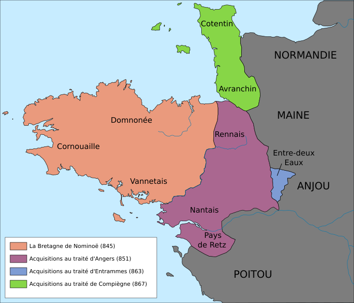
Français : Frontières approximatives du royaume de Bretagne (845-867).
English: Approximate borders of the Brittany kingdom (845-867).
Lambert-93 projection ; RGF-93 datum ; Scale: 1:2,000,000 |
| Date | |
| Source |
|
| Author |
|
| Other versions |
[]
|


Licensing
I, the copyright holder of this work, hereby publish it under the following licenses:

|
Permission is granted to copy, distribute and/or modify this document under the terms of the GNU Free Documentation License, Version 1.2 or any later version published by the Free Software Foundation; with no Invariant Sections, no Front-Cover Texts, and no Back-Cover Texts. A copy of the license is included in the section entitled GNU Free Documentation License. |
This file is licensed under the Creative Commons Attribution-Share Alike 3.0 Unported, 2.5 Generic, 2.0 Generic and 1.0 Generic license.
- You are free:
- to share – to copy, distribute and transmit the work
- to remix – to adapt the work
- Under the following conditions:
- attribution – You must give appropriate credit, provide a link to the license, and indicate if changes were made. You may do so in any reasonable manner, but not in any way that suggests the licensor endorses you or your use.
- share alike – If you remix, transform, or build upon the material, you must distribute your contributions under the same or compatible license as the original.
You may select the license of your choice.
File history
Click on a date/time to view the file as it appeared at that time.
| Date/Time | Thumbnail | Dimensions | User | Comment | |
|---|---|---|---|---|---|
| current | 17:48, 27 February 2013 |  | 700 × 600 (39 KB) | VIGNERON | optimise : clean, crop, etc. |
| 17:31, 7 December 2010 |  | 736 × 624 (72 KB) | Cj73 | Diverses corrections | |
| 18:18, 14 November 2010 |  | 736 × 624 (79 KB) | Fab5669 | Suppression carré noir. Black square deleted. | |
| 12:39, 14 November 2010 |  | 736 × 624 (80 KB) | Fab5669 | {{Information |Description={{fr|1=Carte du royaume de Bretagne (845-867)}} {{en|1=Map of the Brittany kingdom (845-867)}} |Source={{own}} |Author=Fab5669 |Date=14 novembre 2010 |Permission= |other_versions= }} [[Category:Maps of Bretagne |
File usage
The following pages on the English Wikipedia use this file (pages on other projects are not listed):
Global file usage
The following other wikis use this file:
- Usage on be.wikipedia.org
- Usage on ca.wikipedia.org
- Usage on cs.wikipedia.org
- Usage on cy.wikipedia.org
- Usage on el.wikipedia.org
- Usage on es.wikipedia.org
- Usage on et.wikipedia.org
- Usage on fr.wikipedia.org
- Usage on fy.wikipedia.org
- Usage on id.wikipedia.org
- Usage on it.wikipedia.org
- Usage on ko.wikipedia.org
- Usage on nl.wikipedia.org
- Usage on uk.wikipedia.org
- Usage on vi.wikipedia.org
- Usage on www.wikidata.org
- Usage on zh.wikipedia.org