
File:Map BWHA Railway.jpg

Size of this preview: 740 × 599 pixels. Other resolutions: 296 × 240 pixels | 593 × 480 pixels | 948 × 768 pixels | 1,264 × 1,024 pixels | 2,054 × 1,664 pixels.
Original file (2,054 × 1,664 pixels, file size: 915 KB, MIME type: image/jpeg)
| This is a file from the Wikimedia Commons. Information from its description page there is shown below. Commons is a freely licensed media file repository. You can help. |
| Description | Detail from en:Ordnance Survey "New Popular Edition" Sheet 118. Colour highlighting by uploader. | ||||
| Date | |||||
| Source | Scanned by Arthur Rowbottom at http://www.ponies.me.uk/maps/about.html | ||||
| Author | en:Ordnance Survey | ||||
| Permission (Reusing this file) |
|

File history
Click on a date/time to view the file as it appeared at that time.
| Date/Time | Thumbnail | Dimensions | User | Comment | |
|---|---|---|---|---|---|
| current | 16:29, 3 August 2010 |  | 2,054 × 1,664 (915 KB) | Old Moonraker | Suggestions from en:User:Redrose64: grid lines at two-mile intervals and not as shown previously, remove scale accordingly |
| 15:36, 2 August 2010 | 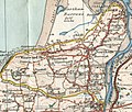 | 938 × 794 (335 KB) | Old Moonraker | Added a scale: gridlines were en:Minute of arc on this edition | |
| 13:30, 2 August 2010 |  | 938 × 794 (218 KB) | Old Moonraker | {{Information |Description=Detail from en:Ordnance Survey "New Popular Edition" Sheet 118. Grid lines at 1000 metres. Colour highlighting by uploader. |Source=Scanned by Arthur Rowbottom at http://www.ponies.me.uk/maps/about.html |Date=1919 |Author=[ |
File usage
The following pages on the English Wikipedia use this file (pages on other projects are not listed):
- Abbotsham Road railway station
- Appledore railway station (Devon)
- Beach Road railway station
- Bideford, Westward Ho! and Appledore Railway
- Bideford Quay railway station
- Causeway railway station
- Cornborough railway station
- Kenwith Castle Halt railway station
- Lovers' Lane Halt railway station
- Northam railway station (Devon)
- Richmond Road Halt railway station
- Strand Road Halt railway station
- The Lane Halt railway station
- Westward Ho! railway station
- User:Bideforddevon/photos
Global file usage
The following other wikis use this file:
- Usage on de.wikipedia.org
- Usage on www.wikidata.org